Despite flooding rains across parts of southeastern Australia this week, there are worrying signs that large parts of the nation are edging towards drought.
The Bureau of Meteorology this week issued its latest drought statement, which showed that areas of rainfall deficiency have developed in parts of all states and territories in the five months from September to May 2023.
You can see the rainfall deficiency areas marked in various shades of red on the map below – the darker the shade, the worse the deficiency.
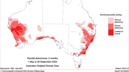
While large parts of the nation are unaffected (the white areas), many of the severe deficiencies are in key food-growing areas, which is a concern for everyone from farmers to customers at the supermarket checkout.
Another worrying pattern in the map is that deficiencies exist in the immediate vicinity of almost all state or territory capitals, which means water storage reservoirs may soon feel the pinch.
“Storage levels remain low in some parts of southern and central Queensland, south-eastern parts of New South Wales, central Tasmania, and urban areas of Perth,” the BoM said in its statement.
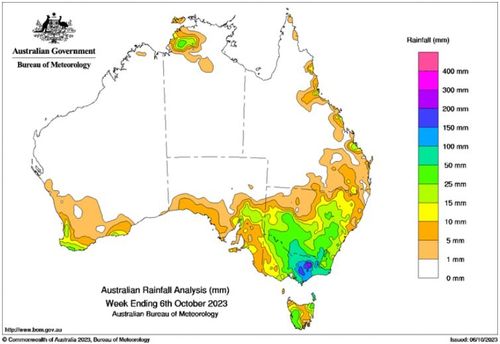
The map above shows the amount of rain that fell in the week up until 9am Saturday.
Read Related Also: CPD officer among 3 pepper sprayed during pro-Israel event, pro-Palestinian rally in Skokie: police
As you’d expect, there was very heavy rainfall (the dark green, blue and purple blobs) in the flood-affected areas of in Victoria and southern NSW.
But only moderate amounts of rain fell in most of the long-term rain-deficient areas visible in the first map, meaning that this week’s event has done little to prevent drought developing further afield as spring turns to summer.
The BoM said in its drought statement that below median rainfall is “likely to very likely” for much of western, northern and southern Australia for November 2023 through to January 2024.
Only small areas of northern New South Wales have a slightly increased chance of above median rainfall in that period, the BoM said.