Grey skies have become the norm and it seems like there is no end to the downpours battering the east coast as Australia rides out its third consecutive La Niña event.
So when will the effects of this third La Niña finally peter out?

The Bureau of Meteorology (BoM) released its latest update this week about the climate drivers in the Pacific, Indian and Southern oceans and the Tropics.
The good news is that La Niña is expected to wane over spring.
The bad news is that a combination of other influential weather patterns still point to more rain on the horizon for this spring and summer.
And while La Niña will grow weaker during spring, its effects are “likely to persist into early 2023”, the BoM report says.
The combined effect of La Niña, along with a negative Indian Ocean Dipole – where ocean temperatures are warmer in the east Indian Ocean than in the west – also means the likelihood of above average rainfall is increased, especially on the east coast.

Then there’s the Southern Annular Mode (SAM), which controls the ring of westerly winds that circle the South Pole.
Read Related Also: Police probe motive behind shooting at Skaf family home
It’s in a positive phase, which generally points to above average rainfall for all of the eastern states – but a lower than average rainfall for western Tasmania.
“The Bureau of Meteorology’s extended and long-range forecasts show that above average rainfall is likely across much of eastern Australia. This reflects the influence of several key climate drivers,” the report says.
The effects of climate change also need to be factored in, the report notes.
“Climate change continues to influence Australian and global climate,” the report says.
“Australia’s climate has warmed by around 1.47 degrees Celsius for the 1910–2020 period. There has also been a trend towards a greater proportion of rainfall from high intensity short duration rainfall events, especially across northern Australia.”
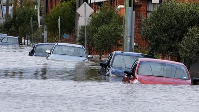
Cars submerged in flooded inner-city streets