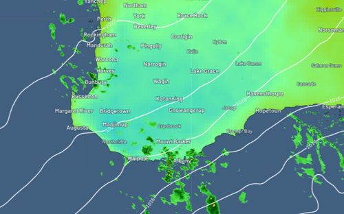
Perth residents are facing a record-breaking wet winter after rainfall totals edge towards a level not seen since in nearly 20 years.
The Western Australia capital’s long-term average rainfall for June, July and August are expected to eclipse the most rain Perth has copped since 1996, according to Weatherzone.
Perth has already been drenched with 129.8mm of rain in June and 174.4mm in July – both surpassing the long-term averages for the usually sunny city.
All the Australian towns with record-breaking weather events
There has been 88.8mm of rainfall so far in August.
The halfway point of the month is nearing and the total just needs to beat 122.7mm to break the 1996 record.
The rainfall streak is forecast continue across WA for the remainder of August.
The Bureau of Meteorology expects more showers over the next week, meaning it is likely the rainclouds will bring down the 34mm needed to beat the monthly average.
A cold front has cast a long rainy shadow across south-west WA already this week.
Today and Friday are expected bring more rainfall and a soggy few days are on the cards from Sunday into early next week.
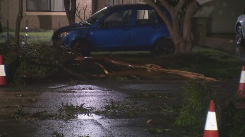
The wet weather brought record-breaking wind gusts overnight to Perth and large parts of WA overnight.
A wind gust reaching 117km/h hammered the Jandakot area, beating the previous record in the area of 113km/h measured in 1990.
The damaging winds and heavy rain brought down trees and even sent debris rocketing across the Perth metro area.
The BoM said these conditions were “normal” for this time of year but warned the wild weather could be dangerous.
A strong marine wind warning is still in place for the Perth local waters area, the Lancelin Coast, the Perth coast, the Bunbury Geographe coast, the Leeuwin Coast, the Albany coast, the Esperance coast and Eucla coast.