I thought I’d take a break from politics and take you on a little dive into one of my – as you might have noticed – favoritest things eh-vah: the weather.
It turns out this is an awesome time of year because lots of weather of unusual size is happening, and this year, spectacularly so. And, as it’s the beginning of winter, I am not the one doing the yearly refresh of our World Famous Hurricane Prep Post, restocking the emergency larder, or hauling out the hurricane shutters as I spend every June to (this year, jeez) November ready at a moment’s notice to do.
When the winds of November come stealing, that sort of attention-grabbing big blow switches latitudes and happens way north of us across both coasts.
The term “bomb cyclone” combines two separate meteorological terms. Contrary to popular opinion, it is not merely a hyperbolic appellation, so hyperventilating TV anchors can sound even more alarming, although it does come off that way.
…What is a Bomb Cyclone?
“Bomb cyclone” is a commonly used name to describe a low-pressure system occurring in the winter that explosively intensifies within a 24-hour period and typically includes heavy snow and strong winds. Specifically, it occurs when the central pressure of a low-pressure system drops at least 24 millibars within 24 hours.
How Did it Get That Name?
The term “bomb cyclone” is a derivation of the meteorological term “bombogenesis,” which is itself derived from “explosive cyclogenesis.”
Are Bomb Cyclones Common Events?
Primarily occurring from October through March, bomb cyclones are not uncommon along the East Coast of the United States. New England’s fabled nor’easters often qualify as bomb cyclones. However these storms can occur in every state…
The downside in the Pacific Northwest is that these big systems can train in one after another with only a few days between. Kind of a bummer – no breaks. That’s normally not the case on the East Coast or for something that fires up after “bombing out” in the middle of the country.
When these bad boys do blow up and roll into the PNW Coast, they bring with them tremendous amounts of moisture, mountainous waves, and often hurricane-force winds. That is precisely what was predicted with the storm forming offshore and forecast to hit this past Tuesday into Wednesday.
According to meteorologists, it looked like a record breaker was in the works.
Just in the next 7-days from the “climate fueled” atmospheric river and mega “bomb cyclone”
8 Trillion gallons of precipitation will fall on California
5T on Oregon and 3T on Washington + 2.5T on IdahoPushing 20 Trillion gallons from this extreme event. pic.twitter.com/wPsi2Xqpoo
— Ryan Maue (@RyanMaue) November 18, 2024
Turns out, it was.
There are plenty of warnings that these things are coming, so the responsible thing would be to batten down the hatches and gas up the vehicles, right?
(Our hurricane prep list works for these situations, too.)
Smart folks who like to be prepared and savvy old timers who did were lucky because the weathermen had it right. This monster dropped pressures to record lows and came screaming in like a Valkyrie.
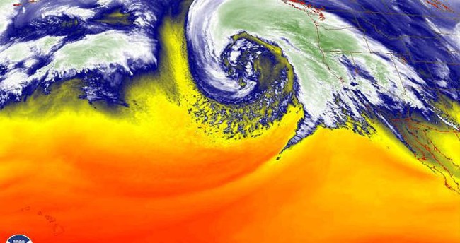
Actually, it was mesmerizingly beautiful from the satellite but hurricane-like enough to give me the willies.
The evolution of today’s bomb cyclone (currently 943mb!) from sun up to sun down! What a thing of beauty. Save this one for the textbooks. pic.twitter.com/e5xOVQfJsC
— Adam Lucio 🌪️ (@AdamLucioWX) November 20, 2024
If only they were so petty underneath the graceful swirl of the clouds.
It proceeded to tear things up.
Video from Bellevue WA of very strong wind gusts knocking down a tree onto powerlines and tree branches flying in the air.
📷: Sada Saleel #BCStormWatch #wawx #BombCyclone pic.twitter.com/Hxkp33U49u
— michael_wx_ (@michaelwx6) November 20, 2024
Had I been on this flight into Seattle, I would have needed a stiff drink afterward. And I definitely would have bought a round for the cockpit crew.
Note: THIS IS ALSO WHY YOU ALWAYS KEEP YOUR SEATBELT FASTENED
So not looking out the window to watch the wings bounce…not…looking…
Incredible skill on display as a plane makes a successful landing in Seattle during strong winds from a powerful bomb cyclone. ✈️💨 pic.twitter.com/NBixTLelUC
— AccuWeather (@accuweather) November 20, 2024
And, no – this isn’t Jim Cantore in Biloxi during Ivan or Mike Siedel on Cocoa Beach.
It’s a couple enjoying a walk in California as the weather moves in.
People struggle to walk in strong winds as a bomb cyclone hits the California coast, causing high waves. pic.twitter.com/aCbO4KKPYS
— AccuWeather (@accuweather) November 21, 2024
The greater Seattle area got hit hard, and there are reports of hundreds of thousands of people still without electricity days later.
For days now, PSE seems to have made no progress in restoring power around Seattle, particularly the East side. They have a placeholder for everyone to expect power restoration at 12 pm on the 23rd, but the power outage number has not been going down at all. Clicking on outages,… pic.twitter.com/wUjpMxnubM
— Safe Seattle (@RealSafeSeattle) November 22, 2024
…but the power outage number has not been going down at all. Clicking on outages, they all show as just reported, with no action taken.
Q13 had a post yesterday listing when different areas will expect power to get restored, but skipped mentioning King County at all.
I know restoring power after a storm is a big task, but this was no hurricane. Like with everything else in our state, we seem to be terribly inept in solving real problems. This is unacceptable.
Can you imagine if we had a big earthquake?
As in the aftermath of every hurricane, there are also inexplicable long lines for gasoline at the few operating service stations (pumps need electricity, so do credit card readers – always have cash if something big might be headed your way).
Then there’s a uniquely NetZero problem when electricity’s scarce.
I wonder how many of these folks in line have their heat on, clearly they have their headlights blazing. Any chance of their batteries running out of juice b/4 they get to the chargers?
— SeaWaDude (@1SeaWaDude) November 21, 2024
I hate to giggle…but you know I am.
While the lines might be long at whatever gas station is open, the guy ahead of you just fills up and drives off. Five minutes, tops.
And the next person in line gets a pump.
I don’t think five minutes does anything for an EV, does it?
Stabbing in the dark here, of course.
And not to rain on anyone’s parade…
The second “bomb cyclone” central pressure drops to 977 mb, not as intense as the monster from earlier in the week that is still going!
That’s the storm that’s now looping south and west in a Fujiwara Effect spin cycle.
Both driving intense atmospheric river into West Coast. pic.twitter.com/r1WOX6Pe1m
— Ryan Maue (@RyanMaue) November 22, 2024
…but Round 2 is incoming.
🌧️⚡️ Just as the region recovers from Wednesday’s bomb cyclone, a new storm is set to hit western Washington! Residents should prepare for heavy rain and strong winds. Stay safe and keep an eye on updates! @komonews #WAWX #StormAlert pic.twitter.com/Vrrl2PLcZ7
— KOMO PHOTOG OLEN (@olenhogenson) November 22, 2024
Remember to stay juiced up when the skies of November turn gloomy.


