
Most of Sydney and large parts of NSW will cop a drenching to end the long weekend as rainfall and strong winds batter the east coast.
Drivers heading back towards Sydney and surrounding regions have been warned to stay alert and be careful on the roads after last night brought heavy rains, with a further deluge to come.
The Bureau of Meteorology said an upper level low above central in-land NSW is heading east towards the coast, bringing with it more heavy rain and some thunderstorms.
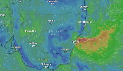
The bureau also issued a warning for heavy rainfall and possible flash flooding for large parts of NSW.
“If you’re travelling for the long weekend or perhaps travelling home for the long weekend, be aware that this heavy rain and the flash flooding may impact your journey,” senior meteorologist Miriam Bradbury said.
“It is worth taking the time to plan out a couple of alternative routes in case you find the roads cut off due to that flash flooding.”
The bureau issued a warning for heavy rainfall and possible flash flooding for large parts of NSW.
Heavy rain is forecast for NSW’s mid-north coast, the Hunter region, the central coast and Sydney’s metropolitan area.
The north-east coast of NSW is expected to be smashed with widespread rainfall of up to 40mm, but localised thunderstorms could bring isolated totals up to 140mm.
Around 117mm was already recorded at Collombatti on the state’s north coast in the six hours until 2.10am today.
Strong and gusty winds may result in dangerous surf across the east coast too.
Peak gusts reaching 90km/h are expected on the Hunter coast and southern mid-north coast of NSW.
The NSW SES has warned long weekend travellers to stay alert, never drive or walk through flood water and to keep clear of storm drains and creeks.
The SES recorded 64 incidents since 7pm yesterday, 14 of which were in Sydney.
Conditions are set to ease slightly by Monday however scattered showers and rain are expected to still develop across the east coast.
Isolated storms are also forecast to impact south-east Queensland and parts of Victoria.
Several minor flood warnings remain in place for areas across Queensland’s south-east and north of Brisbane.