Up next

Inside the world of Andrew Tate
The Bureau of Meteorology (BoM) has today issued a severe weather warning for parts of the Kimberley and North Interior districts amid the “one-in-100-year event”.
The BoM warns today will bring more heavy rainfall and damaging winds, averaging 60 to 70km/h.
Locations which may be affected include Broome, Derby, Cape Leveque, Cockatoo Island, Fitzroy Crossing and Kuri Bay.
Broome Harbour has reported sustained gale force winds from early this morning, with a peak gust of 94km/h.
Six-hourly rainfall totals between 70 to 120mm, with 24-hourly totals up to 200mm are likely west of Derby, and the Dampier Peninsula area is bracing for 24-hourly totals up to 250mm.
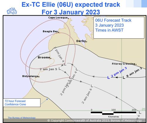
“Ex-Tropical Cyclone Ellie lies to the immediate east of Broome,” BoM said.
“Ellie is expected to be slow moving during today and Thursday before finally moving steadily to the east during Friday.”
The warnings come after the Department of Fire and Emergency Services WA (DFES) declared an emergency situation in the region.
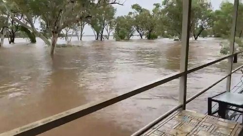
Residents in Fitzroy Crossing are being urged to prepare to evacuate as the town is hit with record flooding.
The town is completely cut off, with the only way in and out by helicopter.
“People in Fitzroy Crossing should be prepared to relocate due to inundation, if safe to do so, and present themselves to the evacuation centre at the Fitzroy Crossing Recreation Centre,” DFES said in a statement today.
“Communities are expected to be isolated for more than seven days.
“There is a possible threat to lives and homes due to rising water levels in local rivers and streams.”
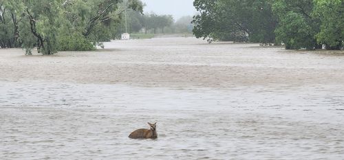
Natalie Davey, one of hundreds of residents forced to evacuate, sought shelter on higher ground.
“It’s coming through like the sea side, there’s a whole lot of water going through my shed,” she said, panning to her porch.
“This is wallabies taking shelter.
“It’s like that everywhere and it’s moving very, very fast.”
Read Related Also: Elon Musk steps on stage with 2-year-old son 'X AE A-XII' in rare outing

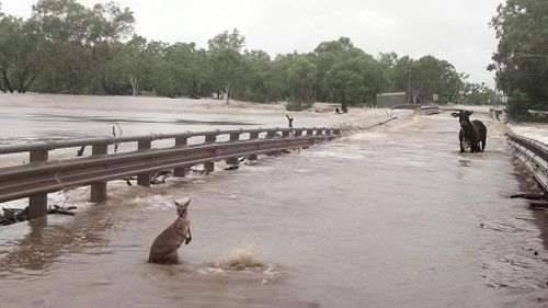
Residents in affected areas have been told to pack an emergency kit that includes warm clothes, valuables, important papers, canned food and water in waterproof bags, and to carefully watch for changes in water levels should evacuation be needed.
The DFES said floodwater could contain hidden dangers such as rubbish, snakes, dead animals, sewerage, live power and other contaminants, and implored people not to enter them.
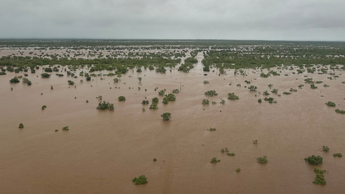
The Fitzroy River is currently sitting at 15.65 metres and is expected to peak around 15.8 metres on Wednesday morning.
This exceeds the 2002 flood record of 13.95 metres.
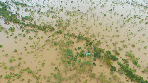

Parts of the small town resemble an inland sea, and with homes going under, the DFES is ramping up it’s emergency response.
“There have been 35 requests for assistance since Monday afternoon including people stranded by flood water and property damage,” it said.
“DFES is bringing in more aircraft to bolster our evacuation and resupply efforts as some communities may be isolated for at least a week.
“Over the coming days, emergency services will need to fly essential supplies to communities cut off by flood water and provide other urgent assistance.”
A number of major roads have been closed across the region as floodwaters encroach.
“People who planned to travel to central or eastern Kimberley over the coming weeks are recommended to reconsider or delay their travel plans,” DFES said.
Post-Christmas heatwave brings back scorching Aussie summer
Relentless march of Ex-Tropical Cyclone Ellie
The cyclone hit the coast as a Category 1 system, and although it was quickly downgraded, it has lingered over the Top End.
Three-day rainfall totals of 200-500mm have been recorded across the Kimberley Region, and 831mm of rain was recorded at a gauge at Dimond Gorge, north of Fitzroy Crossing, over a week-long period.
The storm hit amid cyclone season, which typically runs from the start of November to the end of April.
The BoM warned the season could be exacerbated by La Niña, which can result in more frequent and severe cyclones.
“People in the north of WA experience these types of weather conditions at this time of year but the extended nature of this event and associated flooding is unusual and dangerous,” it said.