Tropical Cyclone Alfred has formed off Queensland, placing meteorologists on alert to track and predict the chances of it turning back towards the coast.
The category 1 storm formed about 4pm (5pm AEDT) today over the Coral Sea roughly 840 kilometres east-north-east of Cairns after swirling around as a tropical low across the weekend.

“When a name matches a prominent person of the time, we reorder to the next name starting with that same letter to avoid any confusion,” a bureau spokesperson said on Friday.
Alfred was expected to strengthen to category 3 by Tuesday morning while heading away from the coast.
However, the Bureau of Meteorology stresses the forecast is uncertain and expects the cyclone to turn towards the south on Wednesday.
“By this point, it’s likely to be the best part of 1000 kilometres off of the Queensland coast, but it will be impacting coastal locations,” bureau meteorologist Angus Hines said in a video update published this afternoon.
“Notice the strong gusty winds blowing up from Brisbane all the way up to areas north of Cairns. “And it will be a windy week along the Queensland coast. We also anticipate showers for most coastal locations, and an increase in the size of the waves, making for some hazardous conditions over Queensland waters.”
No confident forecasts of its possible path have been made beyond Wednesday.
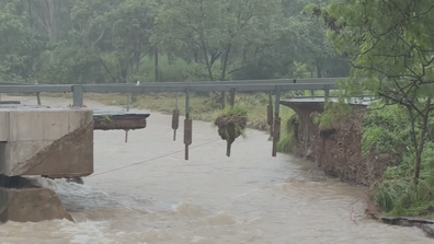
ADF to build temporary bridge to give access to flood-ravaged town
“Considerable uncertainty exists in the track the system will take beyond that, but there is a risk it will move closer to the central Queensland coast later in the week,” the bureau said, in an update.
Hines said the system could drift closer or further away from the Queensland coast than expected, either increasing or decreasing the severity of the state’s weather.
“There are a few paths that this tropical cyclone could take through Thursday, Friday, Saturday at the end of the week, including the risk that it veers back towards the central or southern Queensland coast late in the week,” he said.
“If it does so, that would greatly increase the risk of severe weather for parts of eastern Queensland.
“It is too early to say which parts of the coast are most at risk, and it’s too early to say how strong the winds could be and how much rain could be anticipated.”
Hines urged Queenslanders to keep monitoring forecasts, particularly the cyclone track map, which will be updated with more confident predictions throughout the week.