

More than 109 million Americans from the southern Great Lakes region to as far south as Texas and Louisiana face a dangerous severe weather threat on Sunday, with storms that could pack destructive wind gusts, very large hail and strong tornadoes.
As the strong cold front driving Sunday’s severe storms charges eastward through Monday, some 92 million people from the Northeast southwestward to the central Gulf Coast region will be threatened by another round of severe weather to kick off the new workweek.
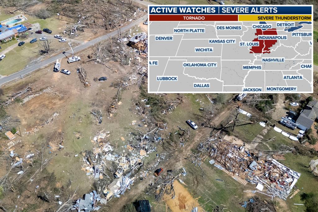
Where is severe weather happening now?
NOAA’s Storm Prediction Center (SPC) has issued a Tornado Watch for northeastern Illinois, northern Indiana and extreme southwestern Lower Michigan until 8 p.m. ET (7 p.m. CT). This watch area includes the city of Chicago.
Another Tornado Watch has been posted for southern into east-central Illinois, central and southwestern Indiana, extreme northwestern Kentucky and extreme southeastern Missouri until 8 p.m. ET (7 p.m. CT). This watch area includes the city of Indianapolis.
Additional watches are likely to be issued later Sunday as dangerous storms continue to fire up throughout the afternoon and evening.
Where are severe storms expected on Sunday and Sunday night?
Numerous severe thunderstorms are expected beginning Sunday afternoon from the southern Great Lakes and Ohio Valley southwestward through the Tennessee and lower Mississippi valleys, with the storms continuing to track eastward into Sunday night.
Initially, the primary threat from the severe storms will be large hail, some of which could be massive (2 inches or larger in diameter, or larger than a lime or hen egg). Several tornadoes are also possible before damaging wind gusts become the more prominent severe weather threat Sunday evening and into the overnight hours.
The SPC has posted a level 3 out of 5 severe weather risk from southern Lower Michigan, including Detroit, southwestward to northeastern Texas and northern Louisiana. These areas face a significant threat of potentially destructive winds that could cause widespread power outages and tree damage.
It should also be noted that any tornadoes spawned on Sunday have the potential to be strong (EF-2 or higher), specifically in a corridor stretching from southern Indiana southwestward to northern Mississippi and eastern Arkansas.
Where are severe storms expected on Monday?
Strong to severe thunderstorms packing threats of fairly widespread damaging winds and tornadoes are expected on Monday from portions of the Northeast southwestward to the central Gulf Coast region.
The SPC has posted a level 2 out of 5 severe weather risk that stretches from central and upstate New York to southeastern Louisiana. However, a level 3 out of 5 severe weather risk covers much of the mid-Atlantic and Southeast, from Virginia to Alabama.
While the highest concentration of wind damage is forecast to be centered over parts of the Carolinas, Georgia, Alabama and the Florida Panhandle, a notable threat extends up much of the East Coast, including major cities along the Interstate 95 corridor such as Washington, Baltimore and Philadelphia.
The damaging winds could take down trees and power lines, potentially causing widespread power outages in some areas.
Another severe storm threat looms for midweek
By midweek, more severe weather is predicted to emerge over many of the same regions expected to be hit hard on Sunday.
The threat begins overnight Tuesday from central and northeastern Kansas eastward to northwestern Illinois, where large hail will likely be the main severe risk.
Wednesday’s severe weather risk area is eerily similar to Sunday’s, stretching from the southern Great Lakes region to Texas and Louisiana. Damaging winds, large hail and tornadoes are all potential hazards from the severe storms.
Additional severe thunderstorms are also possible on Thursday in a corridor stretching from Ohio and western Pennsylvania southwestward to the Ark-La-Tex region.