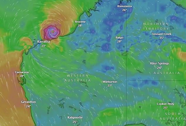
‘Unfathomably’ extreme gusts of wind are set to wreak havoc and leave behind a trail of destruction as Tropical Cyclone Zelia barrels towards Australia.
The category five cyclone is expected to make landfall in Western Australia’s Pilbara region somewhere between Australia’s biggest iron ore export port, Port Hedland, and Karratha.
Zelia is likely to cross the coast either late Friday or early Saturday, bringing winds of up to 320km/h.
Emergency authorities and the Bureau of Meteorology have warned residents in the firing line to take precautions – as the looming cyclone’s exact path remains unclear.
Flights to the region have been cancelled, schools have been shut, and several evacuation centres have been set up in Port Hedland and Karratha, which is 180km south-west.
Major roads, including the Great Northern Highway, and ports in the state’s north-west have also been forced to close.
Cyclone Zelia loomed 145km north of Port Hedland on Thursday afternoon after it quickly developed into the maximum category five system.
Residents have been warned to prepare for the worst.

Category five Cyclone Zelia has been building off the West Australian coast

Cyclone Zelia is expected to bring damaging winds and intense rainfall to the Pilbara region (stock image)
‘This is going to be a big one,’ WA Premier Roger Cook warned.
‘This is a dangerous system. It’s big, it’s strong and it’s very unpredictable.
‘People in the Pilbara need to be prepared, and they need to be prepared now.’
Wind gusts are already up to 285km/h.
‘That is the top of the scale. It doesn’t get any worse than that,’ the Bureau of Meteorology’s Angus Hines warned.
‘That is the most powerful tropical cyclone you can get, and it is forecast to be a category five system as it … crosses the coast.’
‘It’s really hard to fathom wind that strong.
‘That is strong enough to take out complete houses, trees, powerlines and cause widespread damage and disruption.’
Cyclone Zelia comes just three weeks after Cyclone Sean battered the Pilbara region – dumping 274.2mm of rain in just 24 hours.

Meteorologist Angus Hines said the winds will be strong enough ‘to take out complete houses, trees, powerlines and cause widespread damage and disruption’

Residents fear a category five cyclone will wreak even more damage just three weeks after Cyclone Sean caused havoc (above)
Karratha resident Carrie McDowell said the sky was ‘super black’ in the town of about 22,000.
‘We’ve not had a category five while lived here. We had a category three in 2020 and that was really scary,’ she told AAP.
‘I’m a bit worried about flooding.’
A cyclone warning has been issued for an area from Wallal Downs to Dampier, including Port Hedland, Karratha and Dampier, and extending inland to Marble Bar.
A ‘watch and act’ alert is current from Eighty Mile Beach to Dampier, including Karratha and inland to Marble Bar and Millstream.
‘There is a possible threat to lives and homes as a cyclone is approaching the area,’ the alert read.
Heavy rain is set to impact the 450km stretch between Wallal Downs to Wickham, where some locations already recording up to 200mm with ‘a lot more’ to come.
Flood watches have been issued across north-west WA, with the De Grey catchment and Pilbara coastal rivers stretching to the far north-west considered areas of concern.
The cyclone is set to trigger more than 500mm of rain for some areas, with reports of a road train being washed off a bridge at Marble Bar late on Thursday.
Storm surges are also expected to greatly elevate tides at coastal locations near where the cyclone crosses, including around Port Hedland
Rio Tinto, BHP, Fortescue halted exports as Pilbara ports closed.
Rio Tinto said it was too early to predict how long port and rail operations would be shut down.
Meanwhile, the clean-up is continuing in north Queensland after record rainfall eased following almost two weeks of flooding that claimed two lives.
More than $100 million in state-federal grants are now available for flood hit primary producers, small businesses and not-for-profit agencies, with the Queensland government also donating $1.5 million to charity for victims.
Sydney
Friday: Showers. Possible storm. Min 22. Max 30.
Saturday: Shower or two. Possible storm. Min 20. Max. 27.
Sunday: Sunny. Min 16. Max 23.
Monday: Partly cloudy. Min 15. Max 24.
Melbourne
Friday: Shower or two. Min 17. Max 23.
Saturday: Shower or two. Becoming windy. Min 13. Max 18.
Sunday: Shower or two clearing. Min 13. Max 18.
Monday: Partly cloudy. Min 13. Max 20.
Adelaide
Friday: Morning shower or two. Min 17. Max 25.
Saturday: Cloudy. Min 15. Max 23.
Sunday: Partly cloudy. Min 12. Max 25.
Monday: Mostly sunny. Min 13. Max 29.
Perth
Friday: Sunny. Min 16. Max 33.
Saturday: Sunny. Min 18. Max 35.
Sunday: Partly cloudy. Min 20. Max 32.
Monday: Shower or two. Min 19. Max 34.
Darwin
Friday: Showers. Possible storm. Min 26. Max 32.
Saturday: Showers. Possible storm. Min 25. Max 31.
Sunday: Showers. Possible storm. Min 25. Max 31.
Monday: Shower or two. Possible storm. Min 25. Max 32.
Hobart
Friday: Shower or two. Min 18. Max 21.
Saturday: Showers. Min 11. Max 16.
Sunday: Shower or two. Min 10. Max 16.
Monday: Partly cloudy. Min 10. Max 19.


