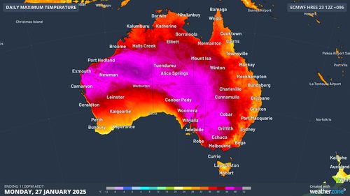
Victorians are being warned to stay cool over the Australia Day long weekend, with the state expected to bear the brunt of a heatwave sweeping parts of the country.
Melbourne is set to reach a scorching top of 42 degrees tomorrow, with extreme fire danger ratings in place across much of the state.
There is no Total Fire Ban in place at this stage, but strong wind warnings throughout Victoria tomorrow also have authorities on high alert.
A late cool change tomorrow will push the temperature down by 20 degrees in just a matter of hours, before a top of 22 degrees on Tuesday.
After an overnight low of 26 degrees, the city is forecast to heat up to a sizzling 35 degrees tomorrow.
Conditions in Tasmania will be hot and windy tomorrow evening, when thousands of cricket fans descend on Hobart’s Ninja Stadium for the Big Bash final.
After a top of 33 degrees throughout the day, the mercury should drop to 27 degrees by the 7.15pm start of play as a cold front moves across the state.
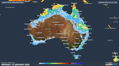
The cold front, combined with a low-pressure trough, is expected to move through the south of the country early in the week, while the east coast is expected to heat up.

Sydney should experience mostly sunny conditions over the next couple of days, reaching 31 degrees tomorrow and 35 degrees on Tuesday.
Temperatures in the west of the city are expected to climb to 41 on Tuesday, before potential storms bring cooler conditions on Wednesday.
Conditions in the ACT will be stormy and hot, ramping up from a cloudy 28 degrees today, before potential storms bring highs of 35 degrees tomorrow and 37 degrees on Tuesday.
Showers and stormy conditions could impact northern parts of WA, the Northern Territory, Far North Queensland and Central Queensland.
Brisbane is expected to cop temperatures of 31 degrees and partly cloudy conditions for most of the week, but the humidity will make temperatures feel a few degrees warmer.
Perth is expecting sunny conditions with tops of 30 degrees today and 32 degrees tomorrow.
The WA capital is set to peak at 40 degrees on Wednesday, with a severe heatwave warning in place for the northern and eastern part of the state.