Sydney weather: Bomb cyclone hits NSW - what you need to know

Welcome to Daily Mail Australia’s live weather blog. 

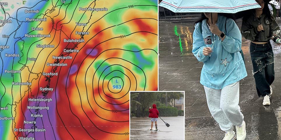
Millions of Aussies are in the path of a ‘bomb cyclone’ which has formed off Australia’s east coast.

Severe weather warnings have been issued for NSW, eastern Victoria and southeast Queensland as the explosive ‘cyclone’ has been confirmed off the coast and heads inland.

Advice to commuters heading to work on public transport

Commuters advised to plan ahead and allow plenty of extra travel time due to severe weather in Sydney and surrounding areas.

‘Severe weather is predicted to impact the east coast of NSW from today. If you’re travelling by train or other public transport, please ensure you take extra care on your journey,’ a Sydney Trains alert read.

Transport for NSW is working closely with other agencies to prepare for the impact.

‘Our message to people who need to travel in those areas south of the low where wind, rain and storms will impact the greatest, including the Mid North Coast, Hunter, Central Coast, Sydney, the Illawarra and South Coast, is to be prepared, stay informed,’ coordinator-general Howard Collins said.

‘Please allow plenty of extra time to get to your destination.’

Commuters wait for their train as trains are delayed due to heavy rain in Sydney on November 28, 2018. - Flights were cancelled, railway lines closed and motorists stranded on flooded roads as a month's worth of rain fell on Sydney early on November 28, leaving emergency services battling to respond. (Photo by Saeed KHAN / AFP)SAEED KHAN/AFP/Getty Images

Flood watch issued for NSW rivers

Flood alerts are in place for many NSW rivers.

‘There is some degree of uncertainty over the exact location and timing of the heaviest falls,’ the BOM said overnight.

‘Localised river level rises, and flash flooding are likely within the areas of heaviest rainfall. If the rainfall moves further inland then higher severities are possible.’

Catchments likely to be affected by minor flooding include Wallis Lake, Myall River, Wollombi Brook and Lower Hunter River, Upper Nepean River, Hawkesbury and Lower Nepean Rivers, Upper Coxs River, Colo River, Macdonald River, Northern Sydney, Southern Sydney, Parramatta River, Cooks River, Georges and Woronora Rivers, Illawarra Coast, St Georges Basin and Snowy River.

Powerful bomb cyclone weather system strikes Australia's east coast: Flood watch issued, flights disrupted

Flights expected to be cancelled

Tuesday’s wild weather is expected to cause travel chaos due to cancelled and delayed flights

A number of flights have already been impacted in and out of Sydney Airport.

Qantas is monitoring the forecasts and has suggested there will be cancellations in and out of Sydney on Tuesday. Customers will be contacted directly.

Jetstar is also understood to be closely monitoring the situation.

Virgin Australia warned on Monday that weather conditions would affect its Sydney and Newscastle schedules.

‘The safety of our guests and crew is our highest priority and we encourage those travelling tomorrow to keep an eye on the status on their flight via our website or app,’ a spokesperson said.

A Jetstar Airlines Boeing 787-8 plane and a Qantas Airways Boeing 737-800 plane line up with other aircraft on the runway at Sydney International Airport on a windy day in Sydney on June 25, 2025. According to local media, Airservices Australia has ordered Sydney Airport to shut two of its three runways, leading to a number of flight delays and cancellations due to high winds. (Photo by DAVID GRAY / AFP) (Photo by DAVID GRAY/AFP via Getty Images)

When will the weather clear?

The East Coast Low is expected to move east further into the Tasman Sea on Thursday afternoon, with heavy rain and strong winds gradually easing as it does so. By late on Thursday, or early on Friday, most of the rain should be offshore, with winds abating as well. The swell is expected to remain large into Friday, but should ease significantly into the weekend.

Source: Weatherzone.com.au

Powerful and hazardous surf warning issued for NSW

Along with the rain, the powerful winds wrapping around the ‘bomb cyclone’ will generate large and hazardous surf, likely leading to significant erosion in some areas of coastal NSW.

Significant wave heights of 5 to 6 m

etres are expected across coasts between Seal Rocks and Batemans Bay, with large waves extending further south and north. Maximum wave heights of 11 to 13 metres are also expected over a similar region.

Source: Weatherzone.com.au

What damage could be caused by the bomb cyclone?

Authorities have warned residents to expect a serious weather event.

‘We are prepared here at the State Emergency Service … but what we need is for you to be prepared,’ NSW SES deputy commissioner Debbie Platz said on Monday.

‘We have been monitoring this system since Thursday of last week and so our state emergency services, including our partner agency, are all very well prepared and planned for this event.

‘We have deployed high clearance vehicles, aerial assets and personnel into the areas which we think will be most impacted by this forecasted weather.’

Fallen trees and power lines are a particular hazard along with flash flooding.

In a high wind weather system, NSW SES recommends securing loose outdoor furniture, bringing pets indoors, seeking shelter away from power lines and trees and low-lying areas, and only travelling if necessary.

The forecasts have those impacted by last month’s devastating floods along the mid-North coast and Hunter region of NSW nervous.

Dairy farmer Michael Jeffery, whose sodden farm lies on the banks of the Macleay River, near Kempsey, said the rain was bringing people’s minds back to May’s catastrophic flood event.

‘It’s been raining all day already and that’s really got everybody on edge,’ he said.

‘It causes a lot of concern, because your livelihood is at risk, all the infrastructure on your farm that’s already been damaged by a flood and you worry about all your cattle and their wellbeing.’

Where will be most affected?

The most intense rainfalls are expected over the Central Coast, delivering up to 200mm of rain.

Affected areas will stretch from the far south of the Mid North Coast, through the Eastern Hunter, Sydney, the Illawarra, and the South Coast, continuing all the way into Victoria’s Gippsland.

‘100 to 200mm of rain possible through these areas over 48 hours, and I expect some locations will pick up even more than that,’ Mr Hines said.

A strong wind warning has been issued by the Bureau of Meteorology for the East Gippsland Coast in Victoria.

A severe weather warning has been issued in NSW for the Mid North Coast, Northern Tablelands and parts of Northern Rivers, Hunter, Metropolitan, Illawarra, South Coast and North West Slopes and Plains Forecast Districts.

Damaging, locally destructive winds are expected along with heavy rainfall.

Flood watches are in place for Mid North Coast, Hunter, Hawkesbury-Nepean, Sydney Illawarra Coast and Snowy catchments.

A harzardous surf warning is also in place for the NSW Coast, along with a generalised warning for Lord Howe Island, which is expected to be smashed with five metre waves.

A marine wind warning is also in place for most of the Queensland coast.

People watch large waves break onto a headland near Bondi Beach in Sydney on April 1, 2025, as large swells and high winds hit the east coast of Australia. (Photo by DAVID GRAY / AFP) (Photo by DAVID GRAY/AFP via Getty Images) 14859813

How much rain is expected?

Bureau of Meteorology forecaster Angus Hines explained that the powerful weather system would batter parts of NSW and Victoria from the start of the week, with up to 200mm of rain expected.

Aussies should be prepared for Tuesday and Wednesday to be the two biggest days when it comes to rainfall and weather impacts.

‘Tuesday’s the day when it is really going to deteriorate, and it’s going to be very wet and very windy, so the rain will likely last through much of the day,’ he told Daily Mail Australia.

‘We will see the winds absolutely howling up that NSW coast.

‘We could certainly see those gusts upwards of 80, 90, even 100 kilometres per hour around parts of the Sydney Metro area on Tuesday – that’s definitely enough to cause a bit of damage, bring down some trees.

‘We could be talking about power outages as well.’

Aussies can expect the affects of the bomb cyclone to last through Thursday.

What is a bomb cyclone?

A bomb cyclone is a term used by meteorologists for bombogenesis, which refers to a storm that occurs when atmospheric pressure suddenly drops below a certain point.

This creates a volatile, fast-flowing air mass which results in a rapidly developing storm.

The pressure drop required for a bomb cyclone in the Tasman Sea, between Australia and New Zealand, is 18 hectopascals near Tasmania to 13 hectopascals near the Queensland-NSW border.

This weather event will see the air pressure plunge by 22 and 24 hectopascals each day, which will lead to heavy rains and high winds.

The low is on course for a 24-hour drop in pressure of around 25 hectopascals, more than reaching the threshold for a bomb cyclone of 15hPa.

Urgent warning issued about the ‘bomb cyclone’ that will smash three states

Millions of Aussies are in the path of a ‘bomb cyclone’ which has formed off the New South Wales coast.

Severe weather warnings have been issued for NSW, eastern Victoria and southeast Queensland as the explosive ‘cyclone’ has been confirmed off the coast and heads inland.

On Tuesday morning, meteorologists warned the system had developed in the western Tasman Sea and would be ‘even more explosive than initially forecast’.

The vigorous coastal low pressure system is expected to deepen throughout the day with damaging winds reaching up to 125km/h, including in parts of Sydney’s east.

Heavy rain and damaging surf conditions, with waves exceeding five metres in the surf zone have also been forecast.

More details in the link below.

You May Also Like

Monday's Final Word

Closing the tabs … Calling for deaths of Jews is now…

Ivanka Trump Left Little To The Imagination In These Skin-Baring Outfits

Romain Maurice/Getty Images For…

Why Anthony Albanese’s radical plan for super will hit FIVE MILLION Aussies – not just 80,000 people Labor claims

Anthony Albanese’s plan to impose a new tax on super balances above…

Country singer Gavin Adcock trashes Beyoncé and her ‘Cowboy Carter’ album: ‘That s— ain’t country music’

It’s a real-life hoedown. Country music star Gavin Adcock, 26, recently targeted…