
Sydney has shivered through its coldest day in over a year this week, with more wet weather to come on the east coast.
Temperatures on Wednesday reached a high of 12.4 degrees, with a maximum daytime temperature of just 11.6 degrees, marking the coldest day over more than a year.
Unfortunately for NSW and parts of Queensland, the wet and cold weather is about to get much worse, according to The Bureau of Meteorology’s Senior Meteorologist, Angus Hines.
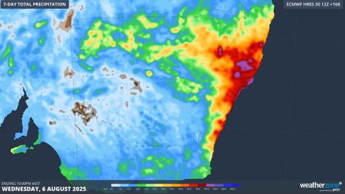
“The bulk of the rain still lies ahead of us,” Hines said.
“The rain seen over the past few days for eastern Australia will be greatly amplified heading into the weekend as a low-pressure area develops off the east coast.”
While the weather system will mostly impact NSW.
“The low-pressure area will be over the water, it’ll have a significant impact for weather in NSW.
“Rain will become heavier, wind will become stronger, and the seas will be more powerful.”
Rain will start to intensify over the weekend, with about 20mm expected today and another 50mm expected tomorrow across NSW.
While there are no severe weather warnings yet, however, there’s a strong possibility the bureau will issue some later today.
“Saturday, this weather system will really make its presence felt. The wind, rain and surf will intensify,” Hines said.
“The Hunter Region and Mid North Coast district will see severe weather.”
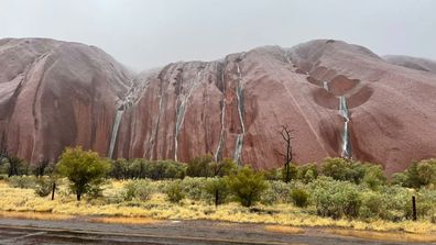
Tourists come across extraordinary sight at Uluru
Between 50mm to 100mm of widespread rain is expected between Port Macquarie and Sydney, down to the South Coast and Illawarra.
Some flash flooding is possible around river catchments north of Sydney.
Damaging winds and surf are also expected over the weekend.
The weather system is expected to clear by Sunday afternoon, with “clearer” and “warmer” weather forecast for Monday.
Queensland has seen about 20mm of rain overnight, with some wet weather expected in the northern tropics.