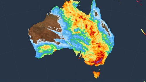
Australia’s eastern states are in for a soggy weekend with a rain band measuring almost 2000km stretching from outback New South Wales to Tasmania.
Warmer sea temperatures off the northern and eastern coast are prompting higher rates of evaporation, meaning more moisture-heavy air is building over Australia, Weatherzone reported this week.
Yesterday saw a band of rain and storms fall from Bourke to southern Tasmania, the weather service said, and there’s more to come in the coming days.
Possible showers are forecast today for Sydney, Melbourne, Canberra and Hobart.
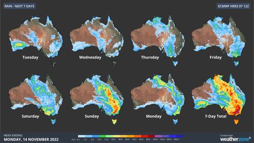
Signficantly, some of the forecast rain to come over the weekend is set to fall in already-flooded areas.
The NSW SES said today it was preparing for a busy weekend.
“This weekend brings the potential of a renewed system that may bring widespread showers and storms, some severe,” the volunteer body said in a statement.
“Localised heavy falls with thunderstorms about the southwest slopes are possible over the weekend. There is a potential of flash flooding and renewed river rises.”
Read Related Also: PayPal punishments for posting memes? UPDATED: PayPal reverses course!
NSW currently has 92 warnings from the SES in place, including 11 at emergency level.
Southern NSW and northern Victoria are forecast to receive the heaviest falls this weekend.
Sydney has a high chance of showers on Sunday and Monday, with temperatures topping out in the high 20C range.
Rain is forecast in Melbourne through to early next week, with potential falls of up to 25mm on Sunday.
However, further up the east coast, Brisbane will stay dry with temperatures reaching 30C on the weekend, though skies will be cloudy.

Roo seeks shelter from floods inside shocked family’s house