The front is expected to bring wet weather along with cooler conditions.
The weather shift comes after it was confirmed multiple March heat records were broken across New South Wales.
Today, the capitals of Canberra and Sydney are looking at a top temperature of 23C and 26C respectively, after clocking sweltering Autumn highs of 37C and 33C yesterday.
Showers and storms are expected to return to south-eastern Australia from Tuesday.
But not all of NSW is basking in the cooler conditions yet.
“Even though that cool change has reached parts of the coast, including the Central Coast and the Sydney area, unfortunately we are still seeing very hot conditions inland,” Bureau of Meteorology (BoM) senior meteorologist Miriam Bradbury told Today.
“(There is) high fire dangers about the slopes and plains of NSW and temperatures reaching the high to mid 30s at least across those inland areas.
“We are going to see conditions becoming milder and more humid over the next few days and hopefully lead to an easing in the fire conditions.”
Read Related Also: Kim Kardashian shares cryptic quote about ‘life with good people’ two years after she filed for divorce from Kanye West
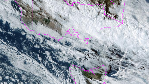
Weatherzone explained the cold front started moving across South Australia, Victoria and Tasmania on Saturday.
“It’s now pushing up over southern parts of NSW, bringing some welcome relief,” the weather service said.

Record heat in NSW sparks bushfires
Half a dozen records fell across NSW during the “unseasonable” heatwave, which lasted several days.
Weatherzone said the sweltering conditions were caused by a pair of slow-moving troughs that moved across from the country’s interior.
“Mudgee soared to 38.3C, its hottest March day in 116 years of records,” it said.
“Both Forbes (40.7C) and Wagga Wagga (39.9C) have had their hottest March day in 83 years, with Bathurst (36.6C) having their hottest March day in 82 years.”
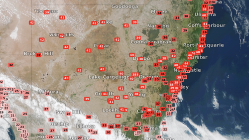
Temperatures also fell at Moss Vale, which reached 37C and has 61 years of records, Orange, which reached 34.5C and has 55 years of records, and Goulburn, where the mercury hit 37.6C, breaking 52 years of records.
Sign up here to receive our daily newsletters and breaking news alerts, sent straight to your inbox.