Two cold fronts surging across south-eastern Australia are expected to serve up daily dustings of snow in the Australian Alps over the next week.
The polar blast has arrived just as the 2025 ski season gets underway this King’s Birthday long weekend.
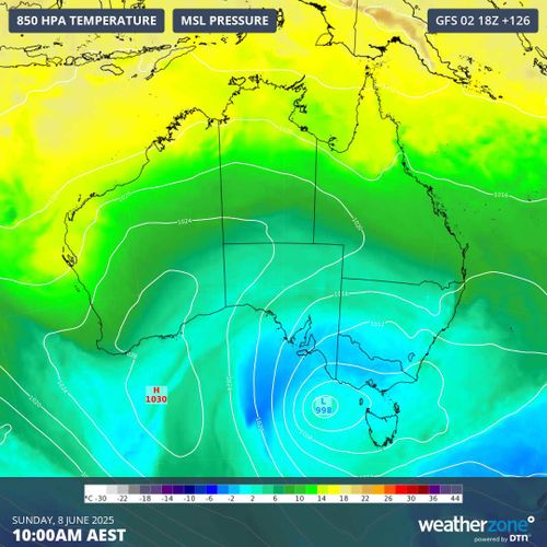
A weak cold front sliding across south-eastern Australia will deliver some light snow to the high mountains in NSW, Tasmania and Victoria, Weatherzone reports.
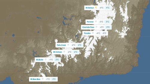
The Bureau of Meteorology is forecasting a small chance of snow on Wednesday in Victoria’s ski fields at Mt Hotham and Mt Buller, with a maximum temperature of -1°C. In NSW, there is also a slight chance of snow falling at Perisher and Thredbo.
From Wednesday night and into Thursday morning, the mercury is expected to plummet, with minimum temperatures forecast to reach -5 to -7°C in the Victorian and NSW Alps.
The snow falls are expected to begin in earnest over the weekend, when two cold fronts are set to sweep across south-eastern Australia, Weatherzone said.
Snow is expected to fall in the mountains each day from Saturday to at least Tuesday.
The cold front will move over Victoria on Tuesday morning. The huge field of speckled cloud to the south of this front reveals a large cold air mass surging towards southeastern Australia.
“It’s still too early to predict exactly how much snow will fall from these systems, although computer models suggest that about 20 to 50 cm could fall across this four-day period,” Weatherzone said.