Large parts of Western Australia are waking to a chilly morning today after a polar air blast brought a rare snow fall to areas with high elevation.
The mercury struggled to reach above 4 degrees in Perth during the early hours and similar temperatures were recorded in many other parts of WA.
A blast of southerly winds has been blowing across the Southern Ocean during the past week, carrying polar air from the ice sheets of Antarctica into unusually low latitudes, Weatherzone reports.
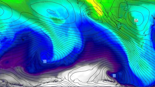
This Antarctic air mass yesterday reached the Stirling Range, about 340kms south east of Perth, with snow falling at Bluff Knoll.
The distance between WA and Antarctica plus the state’s low lying mountains make snow a rare sight in the state.
The highest peak in the state, Mount Meharry, peaks at 1248m above sea level and lies north of the Tropic of Capricorn. While the Stirling Rage is much further south, its highest peak, Bluff Knoll, only rises 1099m above sea level.
Falls on the Stirling Range happen only once or twice a year.
Read Related Also: 'Do you not feel embarrassed?': Qantas CEO grilled at Senate hearing
Despite these factors, the polar air mass that reached the WA’s southwest this week was easily cold enough for snow.
On Wednesday, the collision between the polar air and a warmer weather system caused storms across large parts of WA.
The storms were uncommonly active for winter, with the region already seeing over 44,000 lightning strikes during the early hours.
Sunny and cold weather is forecast in WA for the weekend, with a minimum temperature of 5 degrees tomorrow in Perth.
But the mercury will rise to a maximum of 21 degrees from Monday.

Wild winds rip the roof off WA hotel
Sign up here to receive our daily newsletters and breaking news alerts, sent straight to your inbox.