
The Bureau of Meteorology has issued a warning that a tropical cyclone could hit northern Western Australia tonight.
Currently categorised as a tropical low, the storm is moving east at about 7km/h towards the northwest Kimberley coast, between Mitchell Plateau and Beagle Bay.
The slow-moving storm is forecast to reach tropical cyclone intensity shortly before making landfall on Friday night or Saturday morning.
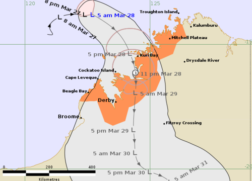
It was last tracked 270km north-west of Kuri Bay and 405 kilometres north-north-west of Derby at 5:42am this morning.
Sustained winds near the centre were last recorded at about 65km/h, with wind gusts of up to 95km/h.
The storm is expected to cross the coast north of Derby between Kuri Bay and Cape Leveque, bringing with it damaging wind gusts of up to 100km/h in coastal areas.
Heavy rainfall is also expected, which could lead to flash flooding in parts of the northern and western Kimberley starting on Friday and lasting through the weekend.
The cyclone is expected to weaken as it travels over land on Saturday and Sunday, the Bureau reported at 2am (local time) this morning.
Weather warnings are currently in effect from Mitchell Plateau to Beagle Bay including Derby.