While the severe thunderstorms have temporarily eased across eastern Australia, the bureau expects them to redevelop about eastern Queensland and north-east NSW from Saturday, continuing into the new year.
“Severe thunderstorms are possible in Queensland between St Lawrence and Redcliffe, although activity will not be as widespread compared to previous days,” senior meteorologist Sarah Scully said on Thursday.
“Isolated gusty thunderstorms are also possible over western South Australia.”
More specifically, the severe thunderstorms are forecast to impact New Year’s Eve and New Year’s Day, which could leave a question mark over fireworks displays in parts of the country.
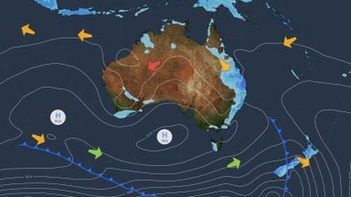
Currently New Year’s Eve, on Sunday, is set to be a wet one right down the east coast with models showing troughs and lows bringing showers and thunderstorms to parts of north and east Queensland, north-east NSW, Tasmania, WA and the north-west NT.
The weather system will maintain heat over the west, east and north of the country, with a high pressure system in the south keeping South Australia dry.
Before the weekend, the bureau says showers and storms are possible across parts of southern and eastern Australia, mainly NSW, eastern South Australia, and northern Victoria.
There’s also a risk of severe thunderstorms about Sydney, the Blue Mountains and the Hunter regions.
Severe thunderstorms are set to become more widespread across the weekend, particularly in north-east NSW, as well as south-east and central Queensland.
Read Related Also: Raquel Welch Secretly Battled Alzheimer’s And Died Due To Cardiac Arrest
“There are indications that isolated, very dangerous thunderstorms with destructive winds, giant hail and intense rainfall may be possible across southeast Queensland on Saturday,” the weather bureau said in its forecast.
There are also some heatwave warnings in place with temperatures across much of northern Australia climbing into the mid-to-high 40s.
In Queensland, Brisbane, the Sunshine Coast and areas surrounding Cairns will see low to locally severe heatwave conditions, which are building along the east coast.
Extreme heatwave conditions are forecast for parts of northern Queensland and in the west, where both Longreach and Julia Creek are forecast to reach 47 degrees this weekend.

Adelaide hit with city’s wettest November day in nearly 60 years
In Western Australia, the low to severe-intensity heatwave conditions are forecast to extend through the Kimberley, eastern Pilbara and Interior districts, reaching extreme intensity in some areas.
Marble Bar is forecast to reach 49 degrees on Saturday and is expected to top 45 degrees for the next six days.
In the Northern Territory, low to severe-intensity heatwave conditions cover most areas. While locally extreme heatwave levels are forecast around Darwin, where warm minimums are leading to uncomfortable nights.