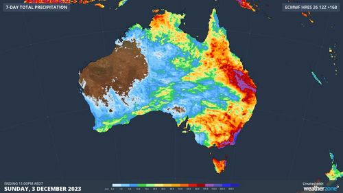
Thunderstorms and heavy rain are forecast for large swathes of south-eastern Australia in the coming days as the wet November continues.
From today, a low-pressure system causing widespread rain across Queensland will move south into western New South Wales.
Forecasters say by tomorrow the system will track towards the coastline, and is set to bring 50mm to 100mm falls of rain, dangerous thunderstorms and damaging winds.
South Australia is also in the firing line for more downpours after being pummelled by heavy rain yesterday.
The Bureau of Meteorology has today issued a severe thunderstorm warning for metropolitan Adelaide and surrounding areas as thousands of homes and businesses remain without power.
The wild weather in the state also caused delays for early flights at Adelaide airport.
Residents should expect heavy rainfall, damaging winds and large hailstones.
Adelaide, Renmark, Clare, Maitland, Murray Bridge and Victor Harbor may be affected.
Read Related Also: TV Show Hosts Who Bashed Donald Trump On Live TV
The State Emergency Service is advising people to secure or put away loose items around properties; move cars under cover or away from trees; keep clear of fallen power lines; don’t drive, ride or walk through flood water; keep clear of creeks and storm drains; stay indoors, away from windows during storms.
There are strong wind warnings today for coastal areas in Sydney, the Illawarra and Eden regions of NSW.
Victoria can also expect strong gusts at Port Phillip, Gippsland Lakes, West Coast, Central Coast, Central Gippsland Coast and East Gippsland Coast.
In Queensland, there are moderate flood warnings for the Moonie River and Wallam Creek.
November has brought widespread rain and thunderstorms over part of every state and territory in Australia.
Some parts Queensland, NSW, the Northern Territory, South Australia and Western Australia have already collected more than three times their average November rainfall.