
Millions of residents in two states are stocking up on tinned food, toilet paper and bottled water as the wildest cyclone in living memory bears down on them, with warnings it could be ‘a real-life nightmare’.
The populations of south-east Queensland and north-east NSW, who are in the direct firing line of Tropical Cyclone Alfred, have been told to prepare their properties before it makes landfall in the coming days.
The cyclone is expected to cross anywhere from Bundaberg in Queensland to northern NSW on Thursday as a category two system, bringing up to 600mm of rain.
Residents have been urged to stay vigilant, pay attention to warnings and prepare for a cyclone so rare in that part of Australia that it is 33 years since the last one hit.
Flood watches and erosion warnings have been issued for coastal areas, with record high 14metre waves recorded off Wide Bay in Queensland on Sunday and the possibility that AFL and NRL games could be affected.
Queensland Premier David Crisafulli said residents should do ‘everything they can’ including having tinned food, making an emergency kit, gathering up passports and clearing debris from properties.
The state government has asked telecommunication companies to increase network capacity to cope with an expected jump in internet usage and millions of messages throughout the emergency.
Many homes in south-east Queensland are not built to withstand cyclones as they are infrequent in that part of the state and Mr Crisafulli urged residents to listen to warnings from authorities.

Residents of south-east Queensland and north-east NSW are in the direct firing line of Tropical Cyclone Alfred and have been told to prepare their properties before it makes landfall. A wild swell at Point Cartwright on the Sunshine Coast, Queensland is pictured on Sunday
‘This part of the state has had its fair share of flooding challenges and has responded well, and I genuinely believe that people will heed warnings and will do the right thing,’ he said.
The cyclone coincides with the AFL season opener in Brisbane between the Geelong Cats and Brisbane Lions on Thursday, while a day later the NRL’s Dolphins and Rabbitohs are set to go head to head at Suncorp Stadium.
‘We will give all sports the information they need, they’ll make their own call,’ Mr Crisafulli said.
An AFL spokesman said the league will monitor the situation over the coming days and adhere to government advice.
Brisbane Lord Mayor Adrian Schrinner said many residents there had never experienced a cyclone before as he stressed the ‘very real threat’ to south-eastern Queensland.
SES NSW urged residents to prepare for damaging winds, large surf and heavy rainfall with major riverine and flash flooding expected from Wednesday.
‘We are asking the community to take steps now to ensure that if you are asked to evacuate you have a plan for yourselves, your families and your pets and know where you will go,’ NSW SES assistant commissioner Dean Storey said.
The cyclone is hundreds of kilometres off Rockhampton and is expected to travel south-east until Tuesday, when it will swing west.

Millions of residents in two states are stocking up on tinned food, toilet paper and bottled water as the wildest cyclone in living memory bears down on them. Stock image of empty shelves in a supermarket

The cyclone is expected to cross anywhere from Bundaberg in Queensland to northern NSW on Thursday as a category two system, bringing up to 600mm of rain

Millions of people are bracing for severe gale-force winds, heavy rain and huge tides as Tropical Cyclone Alfred is set to make landfall (pictured: Townsville in recent weeks)
Modelling has predicted the cyclone is expected to hit Brisbane on Thursday as it slams ashore and creates havoc in south-east Queensland and north-east NSW.
Thomas Hinterdorfer, of Higgins Storm Chasing said the last time a tropical cyclone made landfall as a categorised system in south-eastern Queensland was in March 1992.
That one, Severe Tropical Cyclone Fran, led to beaches being closed on the Gold Coast and Sunshine coasts, and train services cancelled in Brisbane.
Across the state, coastal towns were flooded, trees were uprooted and power was knocked out.
Thirty-three years on, Queenslanders hope history won’t be repeated, but lifeguards closed dozens of beaches from Agnes Water in Gladstone down to Currumbin on the Gold Coast on Sunday in anticipation.
The state has been battered by high winds and massive wave swells over the past few days, with Great Keppel Island’s Hideaway resort evacuated last Thursday.
The category two system, which has been producing wind gusts of 220km/h in the Coral Sea, is forecast to move to the south-east on Monday.
‘Alfred is then expected to slow down and is likely to turn westward from Tuesday, moving back towards the southern Queensland coast,’ the Bureau of Meteorology said.

HMAS Choules charts through rough seas on Sunday, March 2, 2025. A tropical cyclone off the east coast of Australia has halted a Lithuanian rower’s solo quest to cross the Pacific Ocean

The cyclone is headed for Brisbane on Thursday as it slams ashore and creates havoc in south-east Queensland and north-east NSW. Picture: Higgins Storm Chasers

A Bureau of Meteorology weather map shows with south-east Queensland and north-east NSW is in for in the coming days
Community groups have warned the cyclone could have a huge impact on Bribie Island just years after the island’s northern tip was ripped in half by Tropical Cyclone Seth in 2022.
Camping bookings in the area have also barred by Queensland Parks and Wildlife Services.
Pumicestone Passage Catchment Management Body spokeswoman Jen Kettleton-Butler said Caloundra and Golden Beach could face a ‘nightmare’ if the cyclone hit the Sunshine Coast.
‘What’s even more concerning is that within a week, we may see that risk crystallise into a real-life nightmare, as Golden Beach and Caloundra would be sitting ducks if Tropical Cyclone Alfred crossed or lingered near the Sunshine Coast,’ Ms Kettleton-Butler told the Courier-Mail.
‘Emergency action needs to be taken in the next few days to shore up the fragile sections of Bribie Island that will be next to go in a storm event, making fixing the problem even harder and more expensive.’

North Queensland has been hammered by wild weather this year, with winds and heavy rain wreaking havoc earlier this month (pictured: Townsville on February 10)

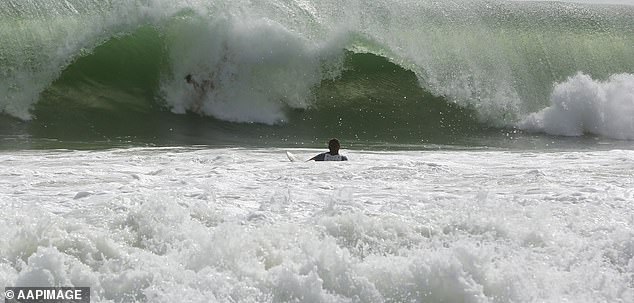
People watch on as a large and increasing swell bears down on south-east Queensland around Point Cartwright on the Sunshine Coast, Queensland, Sunday, March 2, 2025
Premier Crisafulli said ‘we are taking that precautionary approach and asking people to do everything you can to get ready, things like making sure that you’ve got tinned food.’
Authorities are also preparing for the worst case scenario.
‘We’ve spoken to those telcos about making sure that they have back-up power sources if we were to lose power, for example, because we have seen in previous events, how critical telecommunications is and how vulnerable some of those towers are to a lack of power,’ the Premier said.
‘The Queensland Fire Department is in the process of pre-deploying some assets, and making sure that we have the best and brightest ready to respond, and I talk about teams like the swift water rescue team, but indeed, all of those officers.


