The “persistence” of the ex-tropical cyclone has forecasters on high alert.
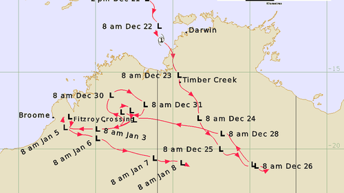
The Bureau of Meteorology tracked the path of ex-tropical cyclone Ellie, from when it formed as a cyclone on December 21, to when it petered out 19 days later.
The Bureau of Meteorology tracked the path of ex-tropical cyclone Ellie, from when it formed as a cyclone on December 21, to when it petered out 19 days later. (Bureau of Meteorology)
Professor Kevin Walsh, an expert in cyclones at the University of Melbourne, branded Ellie’s behaviour “unusual”.

“For Ellie it is very unusual to have remnants going until such a late date” he told 9news.com.au.

“It’s not ordinary behaviour.”
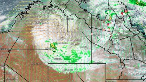
At the end of last week ex-tropical cyclone Ellie continued its slow, relentless march, making its way across southern parts of the Northern Territory.
At the end of last week ex-tropical cyclone Ellie continued its slow, relentless march, making its way across southern parts of the Northern Territory. (Weatherzone )

Walsh said multiple factors could have played into the severity of ex-tropical cyclone Ellie.

“While Ellie is unusual, it’s not unprecedented,” he said.

“There’s been a number of storms in northern Australia, such as Abigail in 2001, that have stayed active and intense for surprisingly long periods of time.

“There are particular meteorological conditions up there that make them possible to do so. For instance if the sandy soil gets wet and it rains very strongly, that combination of factors can cause a lot of heat to go up into the atmosphere.

“It’s an unusual thing, it doesn’t just happen in northern Australia, but it happens particularly strongly there every so often.

“It’s called the Brown Ocean Effect.”

Walsh’s comments come after Weatherzone described the behaviour of the storm as “remarkable”, explaining ex-tropical cyclones usually dissipate within a week of making landfall.
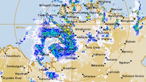
Tropical Cyclone Ellie crosses the NT coast, radar December 23, 2022
Tropical Cyclone Ellie crossed the coast on December 23, 2022 (Bureau of Meteorology)

Meteorologist Joel Pippard said Ellie was able to linger for longer as the system linked to the monsoon trough.

“Usually the moist feed would break off when it got to the interior and the system would start losing moisture and peter out,” he said in a statement.

“That’s what eventually happened on January 8, but over the Boxing Day period it stayed joined to the monsoon trough.”
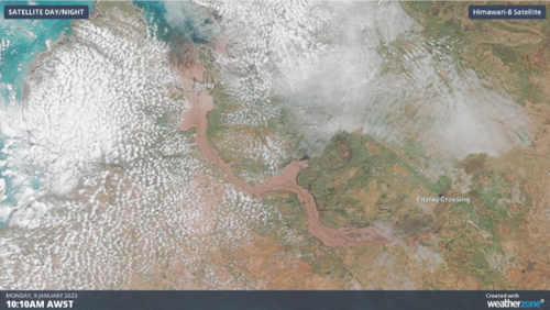
The satellite image above shows WA's Fitzroy River in full flood, after heavy rain generated by ex-tropical cyclone inundated the region.
The satellite image above shows WA’s Fitzroy River in full flood, after heavy rain generated by ex-tropical cyclone inundated the region. (Weatherzone)

Walsh added a La Niña event could also make cyclones more frequent.

“Certainly La Niña increases the chance of tropical cyclones striking the Australian coast,” he said.

“And climate change could increase the severity of future cyclones.”

“This is only one-third into the wet season,” he said.

“We have received some caution about what’s ahead as we are still very much in the wet season and that could have a further impact we have to be mindful of.”
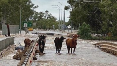
Clean-up begins after flood disaster in WA outback

You May Also Like

Olivia Munn slams ‘gluttonous’ female Blue Origin crew going to space: ‘People can’t afford eggs’

Olivia Munn criticized the all-female, star-studded Blue Origin crew for traveling to…

Well, Lookie Here: Congresswoman and Harvard Prof Are Caught Planning Massive Anti-Trump Riots?

We now know the names of the people leading the “resistance”…

Economist: Trump Isn’t Starting a Trade War; He’s Fighting to Win the Decades-Long War

Economist EJ Antoni, bucking the mainstream hysteria, is explaining that Donald…

Trump's Infamous Hair Almost Flies Away During Liberation Day Speech & The Internet Has A Lot To Say

Andrew Harnik/Getty Images Hold…