New satellite images from Maxar Technologies are giving the best view yet of just how many buildings are on fire in the Palisades and Eaton wildfires in Los Angeles.
The images were taken at 10.45am (local time), during a time of significant cloud cover across the Los Angeles area.
Because of that, they are a mix of shortwave infrared and visible satellite images.
Shortwave infrared sensors on Maxar’s satellites allow them to detect more things on the ground than are in the visible light spectrum, which is visible to the naked eye, such as heat signatures.
Everything illuminated in orange or white indicates locations where fire has been detected.
The imagery shows the Eaton wildfire has set nearly every building in western Altadena on fire.
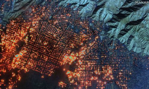
From the Altadena trailhead to the Mountain View Cemetery, the shortwave infrared sensor shows nearly every block is on fire.
Those fires continue nearly all the way to Altadena’s east.
In additional images, fires were also detected on Fair Oaks Avenue and the homes surrounding it.
The infrared sensor also detected a fire at the building that houses the Bunny Museum, located along Altadena Drive.
Significant cloud cover obscured much of the area scorched by the Palisades Fire, but the infrared was able to detect exactly where much of the fire is centralised – the Parker Mesa area, the Summit neighborhood and Pacific Palisades.
A majority of the homes along the Pacific Coast Highway, near Tuna Canyon Road, have been destroyed.
At least one of them is seen on fire in the satellite image.