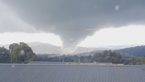
Much of New South Wales is on flood watch this morning with the State Emergency Service (SES) issuing 57 flood warnings across the state – stretching from the far north to the Victoria border – and warning about potential tornadoes.
Today three states are in the firing line of the big wet, with south east Queensland and Victoria also bracing for storms and potential flooding.

In NSW more heavy rain is expected to fall from late today, SES spokesman Jason Simms said, before confirming the service is also on alert for potential tornadoes.
“The SES have preemptively deployed personnel to various parts of the state within the potentially impacted area,” Simms told 9News.
“SES volunteers are on high alert.
“(But) with tornadoes and destructive storms it is hard to predict and the lead time is minimal.
“As with all severe storms, the best idea is to stay indoors, away from windows, unplug electrical devices and stay away from fallen trees and power lines and clean up around the yard.
“Make sure there is no loose material.”

The Bureau of Meteorology (BoM) has issued a strong wind warning for the Macquarie Coast, Hunter Coast, Sydney Coast, Illawarra Coast, Batemans Coast and Eden Coast today.
Tomorrow this will extend to Sydney Enclosed Waters, Coffs Coast, Macquarie Coast, Hunter Coast, Sydney Coast, Batemans Coast and Eden Coast.
The warnings come as a trough and a cold front cross the state, forming a low pressure system.
NSW Emergency Services Minister Steph Cooke warned Saturday will be a “danger day” for Sydney and surrounds.

Simms said an excess of 50mm of rain could fall around saturated catchments in Sydney, central west, the Illawarra and South Coast in the coming days.
“The main areas of concern are Forbes, Gunnedah, and Warren,” he added.
“They may experience some significant flooding this weekend.
“We also are concerned with parts of the Hunter, which may also see some major flooding.
“Flash flooding, localised flooding caused by severe storms is also a possibility throughout much of inland New South Wales, Sydney, and the Illawarra.
“There is a chance of severe thunderstorms across western and southern parts of NSW.”


Much of the flood risk is in the state’s central and north west with the SES issuing 14 “watch and act” notices across the region.
Read Related Also: Lindsay Lohan cozies up to husband Bader Shammas on Christmas
Bourke is one of the areas on alert, with SES writing: “The Darling River at Bourke is likely to reach the moderate flood level (11.40 metres) around 12-14 October.
“The river level may reach around 12.00 metres during late October, with further rises possible.”
The outback town had its wettest October day in 67 years recording 45.4mm.
Weatherzone said an end to the wild conditions is in sight.
“The silver-lining to this wet week is a broad high pressure system moving in from the weekend, allowing skies to clear and days to warm up early next week,” it wrote.
Overnight the SES had 188 calls for assistance, and conducted eight flood rescues.
:saturation(1.44)/https%3A%2F%2Fprod.static9.net.au%2Ffs%2Fb8a4ec0f-afb5-4fd0-9ab2-a08365ce9c7b)
Storms sweep mountains of bluebottles ashore on Sydney beach
Queensland and Victoria
A trough will pass over Queensland from Saturday, which is expected to bring about 40-60mm of rain to some sections of the south east.
Half a dozen flood warnings have been issued for the Sunshine State.
However, meteorologists are closely watching a strange phenomenon swirling off the coast, Today weather presenter Tim Davies said.
“What has got forecasters really concerned this morning is what’s being called a ‘cool pool’, this weird weather phenomenon,” Davies explained.
“There is a section of the ocean just off south east Queensland here on the Gold Coast that is much cooler, below average temperatures in the ocean. This pool, is actually expanding in size and that is what forecasters are keeping a very close eye on.
“What their concern here is that the cooler, below- average temperature water mixes with the warmer waters, particularly as it starts to warm up closer to summer, and that could lead to convection and of course a greater chance of flooding events.”
Victoria is also bracing for showers and potential thunderstorms today.
It is predicted to hold until early 2023.