
About 300,000 homes and businesses remain without power in Queensland, as well as another 13,000 in New South Wales, as ongoing thunderstorms and substantial damage to trees complicate efforts to re-establish supply.
Hundreds of schools across Queensland and New South Wales are likely to remain closed tomorrow, some with significant damage to buildings and many without power.

Emergency warnings across south-east Queensland were replaced by instructions to monitor conditions with one major exception on the southern Gold Coast.
Those in Currumbin, Currumbin Valley, Tallebudgera, Tallebudgera Valley and Elanora were warned to go “inside and up high” and avoid driving anywhere.
“Roads are now likely to be flooded. If you are near floodwater, you may need to get up as high as you can to survive,” authorities said.
“Follow your emergency plan if you are in danger. If you do not have a plan, it may be too late to leave safely.
“If it’s flooded forget it.”
The wider Gold Coast was on a lower watch and act warning to prepare for moderate to major flooding.
Across the border, the evacuation order for the Lismore CBD was lifted today with residents advised to return home “with caution”.
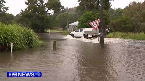
The Bureau of Meteorology warns locally intense falls remain likely across Queensland’s Southeast Coast and southern Wide Bay and Burnett, possibly including Brisbane, Ipswich and the Sunshine Coast.
Six-hourly rainfall totals between 150 and 180mm and 24-hourly totals between 250 and 350mm are possible.
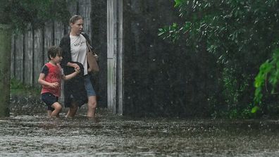
Suburban streets transformed into rivers as Alfred inundates towns
Heavy rain is also expected to continue across the border, in parts of the Northern Rivers, Mid North Coast and eastern parts of the Northern Tablelands extending into the Northwest Slopes and Plains.
Six-hourly rainfall totals between 50 and 100mm and 24-hourly rainfall totals between 100 and 150mm are possible.
The rain and wind gusts are expected to ease by Monday afternoon as Alfred continues to weaken and moves further inland.
More than 3000 insurance claims have already been lodged with thousands more expected as the focus of authorities now turns swiftly towards recovery.


