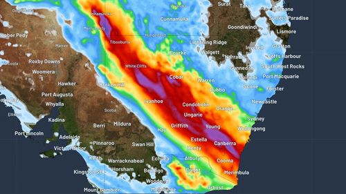
Kirrily was a category two storm when it hit the coast just north of Townsville on January 25.
Since then, it has brought record-breaking rain to northern Queensland and the Northern Territory before hitting South Australia.

Today, the remaining low-pressure system will hit north-west NSW.
Weatherzone said 50mm to 100mm of rain had landed in south-west Queensland, north-east SA and north-west NSW during the 24 hours to 9am yesterday.
The heaviest fall noted was 113mm at Bedourie in Queensland’s Channel Country, its wettest February day in 47 years.
Weatherzone said clouds, heavy rain and thunderstorms could be expected across NSW this morning, with some wet weather even affecting eastern Victoria and the Australian Capital Territory.

Victoria roasts on hottest day of summer
Falls of up to 150mm in places could be expected over 24 hours.
However, a severe weather warning for parts of NSW and the ACT was cancelled by the Bureau of Meteorology this morning, with reports the remnants of ex-cyclone Kirrily had weakened.
A flood warning remains in place for western NSW.


