Evacuation orders have been issued across multiple communities in Moreton Bay while thousands more residents have been ordered indoors as severe thunderstorms and floods continue to batter south-east Queensland this afternoon.
Residents in low-lying parts of Beachmere in the Moreton Bay region have been ordered to evacuate due to rising floodwaters.
The streets subject to the evacuation orders are Beachmere Road near Adcock Road, Bakers Flat Road, Newman Road, Goong Creek Road, Timothy Esplanade and Whiting Street.
A fresh evacuation order has also been issued in Caboolture for residents on King Street near the water treatment plant.
The Caboolture River water level gauge on King Street was sitting at nine metres and rising at 12.05pm – five metres above the usual creek level.
Emergency services are warning flooding above ground floor level could occur in some places and access roads and train lines may go underwater, cutting off communities.
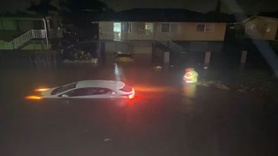
It comes after dangerous flash floods left families trapped inside their homes overnight, with emergency services conducting water rescues for families who requested help in the Moreton Bay, Somerset, Lockyer Valley and Darling Downs regions.
The intense rainfall has continued today, with the Bureau of Meteorology issuing warnings of multiple “very dangerous” thunderstorms that could bring “life-threatening” intense rainfall and flash flooding.
Caboolture was in the eye of one slow-moving storm, with the City of Moreton Bay advising all residents to stay indoors.
Dozens of roads across Moreton Bay are closed due to flooding, including many in Caboolture.
The floods have also disrupted train services, with delays of up to an hour on the Caboolture, Sunshine Coast, and Redcliffe Peninsula lines after trains had to be stopped due to flooding over tracks at Bray Park.
Residents are being urged by Queensland Fire and Emergency Services to remain in their homes until the wild weather ceases.
“If conditions are dangerous in your area, avoid unnecessary travel and stay inside until the storm has passed.”
Large parts of Queensland recorded heavy rainfalls overnight. Samford in Moreton Bay received 300mm in just three hours, while the Central Highlands recorded about 71mm in two hours.
Today a severe weather warning remains in place over a huge stretch of land, from Bundaberg in the Wide Bay-Burnett region down to Ipswich.
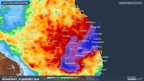
Widespread falls of 100mm to 150mm are forecast between the Gold Coast and Gladstone area in the next 72 hours, with isolated pockets around 150-300mm.
A coastal trough is developing bringing wet and unstable weather.
The most intense rainfall is expected between this evening and tomorrow morning, as a low-pressure system develops within the trough.
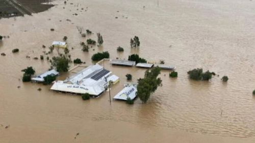
A month’s worth of rain was dumped over just a few hours yesterday as the impact of Ex-Tropical Cyclone Kirrily continues to be felt in north and central Queensland.
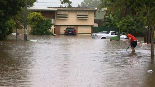
Roads cut off, cars submerged as rain batters south-east Queensland
The remains of the cyclone, currently east of Middleton, will slowly move across the western interior until Wednesday.
It is forecast to bring heavy rainfall which may lead to flash flooding in the south-eastern North West, western Central West, northern Channel Country and far south-western Northern Goldfields and Upper Flinders districts.