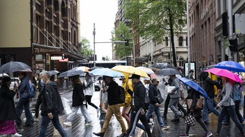
Residents along Australia’s east coast are in for an extremely soggy start to the week, after parts of New South Wales’ copped a drenching overnight.
Some regions in the state’s south recorded over 100mm of rain in the early hours of this morning, with “an unstable trough” wreaking havoc around the Jervis Bay region in particular.
Forecasters warn more rain is on the way.
It comes after Point Perpendicular recorded a whopping 115.4mm between midnight and 9am this morning, including almost 60mm in under an hour.
Jervis Bay airfield recorded 67.4mm in the 24 hours to 9am, with over 67mm falling since midnight.
“The trough is a lingering by-product from the low-pressure system that developed east of Tasmania late in the week, retaining significant moisture as it crawled up the NSW coast, digging in against a building high pressure ridge moving across southeast Australia,” Weatherzone said.
“The slow moving nature of this trough allowed rainfall to accumulate very rapidly.
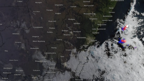
“As the sun rose this morning, the cloud bank was brightly visible on the satellite image as it approached Sydney.
“It continued north and delivered more subdued rainfall totals across Sydney and the Central Coast during the afternoon, with 10.2mm falling in the Sydney cups, and 8.6mm over Gosford since 9am AEDT this morning.”
Read Related Also: Is Trevor Lawrence Wife Pregnant? Baby Family And Net Worth
The trough is set to continue moving up the coast, before “giving way to moist easterly winds along the northern NSW coast”, bringing more dreary weather and potential thunderstorms into the early part of the week.
Meanwhile, the Bureau of Meteorology (BoM) issued a thunderstorm warning for parts of the NSW Central Coast.
The BoM said flash flooding is possible with the Calga, Terrigal, Erina, Gosford, WoyWoy and Umina regions all likely to be affected.
Sydney’s metro could see up to 20mm rain today, with temperatures expected to peak at just 21 degrees.

At least 16 killed, others buried in Ecuador landslide
Elsewhere around the country, Melbourne will see partly cloudy conditions today with tops of 18 degrees and the chance of showers.
It’ll be a sunny day in Adelaide with conditions set to peak at 19 degrees, 26 and cloudy in Brisbane, 19 degrees and cloudy in Canberra and 26 degrees in Perth.
Sign up here to receive our daily newsletters and breaking news alerts, sent straight to your inbox.