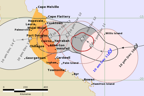
Cyclone Jasper is expected to make landfall in Far North Queensland as a category two storm on Wednesday, bringing gale-force winds and heavy rainfall.
BoM predicts the cyclone will hit between Cape Flattery and Cardwell and towns along the tropical Queensland coast between Cooktown and Innisfail, including Cairns and Palm Island, are all within the warning zone.
“We can expect impacts from the cyclone within 24 hours including gale-force winds,” meteorologist Laura Boekel said earlier today.
“There are large amounts of rainfall associated with cyclones and this cyclone included.”
She said low-lying areas were especially vulnerable and should expect flooding.
In Cairns, the airport remained open tonight but was expected to close, and roads were expected to be cut off by the storm.
Cairns Hospital and the aged care facility next door activated their emergency plans, and all the entrances were being sandbagged.
Elective surgeries on Wednesday were cancelled in order to free up staff.

In storm shelters being set up, people will be given one chair and all their belongings, including snacks, will need to fit underneath it. Water will be provided.
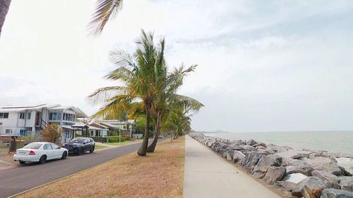
Port Douglas, about an hour north, is also in the firing line for heavy rain, intense winds, flash flooding and tidal surges.
People are being urged to use tomorrow to prepare as the cyclone is forecast to make landfall on Wednesday.
Even the Christmas tree in the town centre has been removed so it doesn’t become a projectile.
Nearly 100 kilometres south of Cairns, Innisfail locals are preparing for isolation, and the warning level is sitting at watch and act.
People have been warned which areas are likely to be impacted by the storm and possible king tides.
“We’re well prepared, we’re now monitoring the system waiting to see what the next move is going to be,” Cassowary Coast Regional Council Mayor Mark Nolan said.
In 2006, the city was flattened by Larry, and then hammered again by Yasi in 2011.
Read Related Also: Taylor Swift’s rip-resistant Sheertex tights are 65% off right now
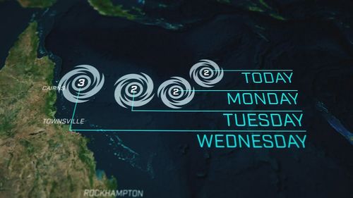
If the system is slower and crosses overnight on Wednesday or Thursday, there is a slim chance of it crossing as a category 3, according to BoM.
Rainfall totals between 100 to 150 millimetres are expected every six hours and 350 millimetres in 24 hours is possible near Cardwell.
Damaging winds up to 90km/h hours are expected between Cooktown and Townsville (but not including Townsville).

The state’s emergency responses are on alert, with BoM to release an update every three hours.
Police Commissioner Katarina Carroll said 45 officers from the south would be deployed to the north, to assist vulnerable areas in preparation.
Carroll said it was more people were travelling on the roads due to the school holidays
“There will be a lot of rainfall in a short amount of time, which obviously leads to flash flooding,” Carroll said.
“If it is flooded please forget it.”
Residents are urged to be prepared to shelter for 72 hours and have their emergency kits ready.
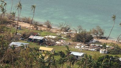
In pictures: Clean-up begins as Fiji reels after deadly cyclone
Many towns are expected to lose power supply in the cyclone.
The Cairns ferris wheel has already been packed down but it’s the crucial infrastructure that’s of greater concern.
Residents are being warned of king tide surges, which are likely.
Cyclone Yasi was the last major cyclone to hit Queensland, near Mission Beach about 130 kilometres south of Cairns, and was a category five at its peak in 2011.