Cyclone Errol has formed off the north-west coast of Western Australia, where forecasters think it will head out to sea and strengthen before doubling back towards the Kimberley.
The category 1 storm formed last night and was 475 kilometres north-north-west of Broome at 8pm (10pm AEDT).
The Bureau of Meteorology expects the system to keep heading almost due west before making a U-turn and strengthening to category 3 on Thursday morning.
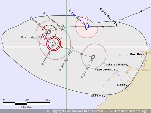
It’s too early for any predictions of landfall but the outer winds could be affecting roughly 400-kilometre stretch of coastline, from just north of Broome to a little north of Kuri Bay, by Friday night.
Although the storm is forecast to again weaken, back to a category 1 storm by that point.
“Tropical Cyclone Errol is well to the north of Broome and moving west,” the bureau said last night.
“It is expected to continue moving west and intensify during Wednesday.
“From Thursday Errol is expected to turn southeast towards the coast and weaken.”