The Bureau of Meteorology has issued a warning that a tropical low in the Gulf of Carpentaria may develop into a tropical cyclone tomorrow.
There is a 55 per cent probability that the tropical cyclone could form, with the Bureau estimating it may make landfall by Monday.
A tropical cyclone watch has been declared from Groote Eylandt in the Northern Territory to the Queensland Border.
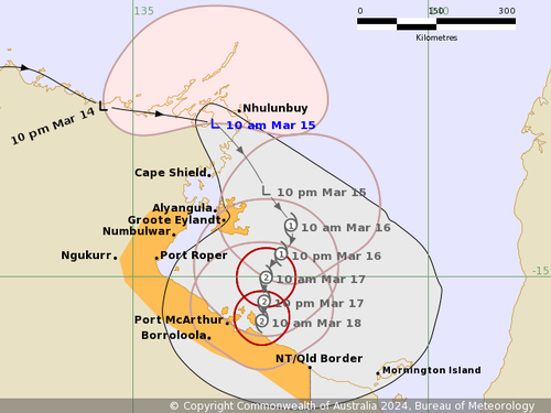
The current Tropical Low 09U is forecast to develop into a category 2 storm before crossing the southwest coast of the Gulf of Carpentaria, most likely during Monday, the Bureau of Meteorology said.
“During next week the system should move west or southwest through the Northern Territory as a tropical low.”
The storm has a high (greater than 65 per cent) chance to develop into a tropical cyclone.
If it develops into a tropical cyclone, it will be named Tropical Cyclone Megan, according to the Bureau of Meteorology.
The Bureau’s warning comes amid forecasts of thunderstorms in the Western Cap York area with a danger of flash flooding.
Meanwhile Brisbane’s overnight temperature last night dropped below 20 degrees C for the first time since January 1 – falling to 19.8ºC at 5.30am.
This broke a 74-day run of consecutive nights above 20.