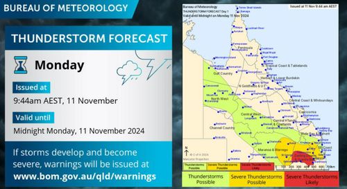
Queenslanders are bracing for several days of extreme weather, including thunderstorms and a scorching heatwave.
Violent weather already lashed the state’s south-east overnight, with concerts cancelled and thousands evacuated during the severe spring storm.
The sell-out A Day on the Green outdoor concert was a washout, British pop star Sophie Ellis-Bextor was forced to abandon her Sirromet show, and Take That also pulled out due to safety.
Out west copped it too, with Mother Nature unleashing a wild combination of fire and rain.
Ian Stark faced a fire, with $30,000 worth of hay bales going up in flames on a bull farm at Dalby.
“Frequent hits of lightning and one of those happened to hit our stack of hay,” he said.
The weather bureau warns there’s more of that on the way for the next few days.
The thunderstorms are set to hit southern inland parts of Queensland east of Charleville, primarily impacting the Southern Downs and Granite Belt.
The worst of the storms will bring heavy rainfall tonight.
:contrast(12):saturation(1.48)/https%3A%2F%2Fprod.static9.net.au%2Ffs%2Fac33da02-4ef0-4bba-9022-8df49cbc6aa2)
Mystery of pink sand washing up on South Australia’s beaches solved
Thunderstorms are forecast for the north-west and central west belt of Queensland, with conditions set to worsen towards the south-east coast.
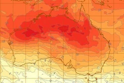
Meanwhile, heatwave conditions have been gripping large parts of Queensland.
In an emergency warning, the bureau said the severity of the temperatures may pose a health risk in the Cape Peninsula area.
Low to severe heatwave conditions were set to impact far north, northern, north-west, central and central-western Queensland today.
Maximum temperatures were forecast to be the high 30s to low 40s while minimum temperatures in the mid to high 20s.
“Severe heatwave conditions are building over the north with isolated pockets of extreme heatwave conditions expected to develop in the coming days,” the Bureau of Meteorology said.
“Severe heatwave conditions are expected to ease over central districts as the heat moves north.”