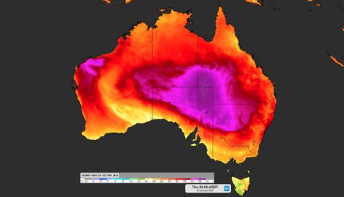
The heatwave smothering large parts of eastern Australia is continuing today, with more scorching conditions for New South Wales and a potential new heat record in Queensland.
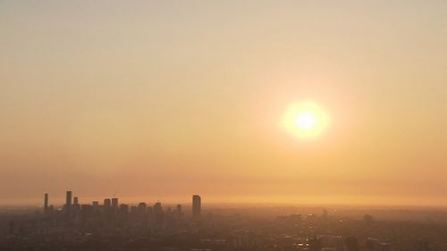
The mercury is set to climb to 35 degrees in central Sydney today, but the city’s western suburbs will feel the heat most. Residents in Penrith can expect a top of 37 degrees and Parramatta 36 degrees.
It will be cooler in coastal suburbs: Bondi in the Eastern Suburbs hitting a maximum temperature of 31 degrees and the same for Mona Vale on the Northern Beaches.
There is a chance of a thunderstorm and rain in Sydney later today.
But high humidity will increase the impact for Sydneysiders. A humid air mass could make the temperature feel five to 10 degrees hotter than the actual temperature.
Driven by warm north-westerly winds, temperatures tonight could challenge the January minimum record of 26.2 degrees or even the all-time minimum mark of 27.6 degrees.
It will mean another muggy night in store for the city and a warm start to Australia Day tomorrow.
Regional NSW is also heading for another scorcher today. Many towns and regional cities can expect temperatures in the low to mid-40s.
But there is relief in sight before the weekend. Temperatures are forecast to drop by 10 to 15 degrees when a southerly change begins after noon tomorrow.
The heatwave is being caused by a large mass of hot air that earlier this week produced the warmest morning on record for Queensland and the hottest day Adelaide has recorded in three years.
Now, this heat is tracking further east, driving the stifling heat across large areas of New South Wales, Queensland and the ACT.
Meanwhile, Queensland could challenge its temperature record today, which was set at Birdsville in the state’s far west in 1972 when the mercury reached 49.5 degrees.
The Outback town’s maximum temperature is forecast to reach 49 degrees, but if it reaches more than half a degree warmer, it will set a new record.
While Sydney will be much cooler on the weekend, the hot conditions will continue in Brisbane, with temperatures forecast to reach the mid-30’s.