Tropical Cyclone Alfred is expected to make landfall late on Thursday evening or early Friday morning, bringing with it intense rainfall and high risk of flooding.
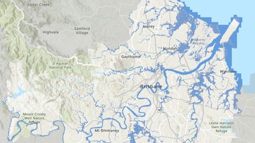
Flood mapping has shown that almost 20,000 homes are at risk of flooding in Brisbane alone when the storm hits.
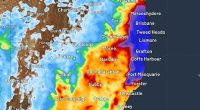
Flood warnings have been issued in south-east Queensland and north-east New South Wales, with flash flooding and burst waterway banks predicted in the days ahead.
Low-lying suburbs near rivers and creeks are considered to be at most risk, as are beachside communities which could be affected by storm surge flooding.
Today, Bureau of Meteorology senior meteorologist Christie Johnson warned floods could start as soon as this afternoon and Queensland Premier David Crisafulli warned people to prepare for evacuations.
“I have seen the way that the south-east has handled flooding events and I’ve seen the way that Queenslanders have dealt with all forms of challenges like this, and I have every faith that the state will come through this,” he said.
Brisbane Lord Mayor Adrian Schrinner issued a warning today that “almost 20,000 properties across Brisbane could be impacted by storm surge or flooding”.
”According to the modelling, areas most at risk include Nudgee Beach, Brighton, Windsor, Ashgrove, Morningside and Rocklea,” he said.
Other areas at significant risk of flooding in Brisbane include Coopers Plains, Carina, Sandgate, Hemmant, Lota, Tingalpa, Indooroopilly, Albion, Bardon and Wynnum West.
“We are advising people to make a plan in those areas,” Schrinner said today.
“As the Premier said, the first option will be to stay with family and friends. You will be safe and more comfortable by staying with family and friends.”
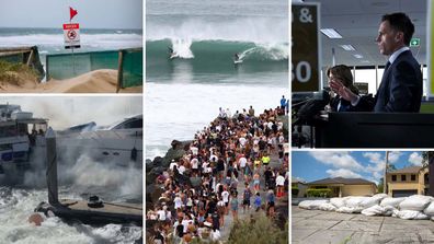
Beaches closed, shelves empty as Cyclone Alfred approaches
Brisbane city council, Moreton Bay council, and Gold Coast council have directed locals to monitor flood warnings and mapping online.
Residents can search their address to learn how their home and local area may be impacted on their local government’s disaster dashboard. A list is available here.
Over the border, parts of northern NSW are also bracing for floods as Cyclone Alfred creeps closer to the coastline.
NSW Premier Chris Minns said the state government is bracing for a worst-case scenario “akin to the 2022 natural disaster”.
The northern NSW floods claimed nine lives and ravaged thousands of homes and buildings from Cudgera Creek to Tweed Heads.
The premier urged people concerned about flooding to evacuate their homes by Thursday evening.