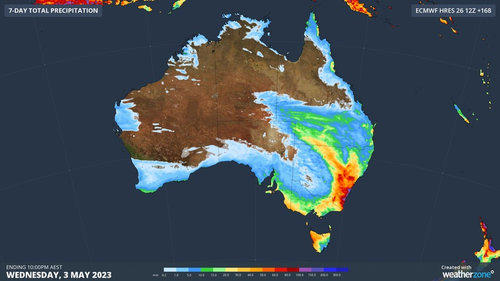
Much of Australia is bracing for a multi-day deluge over the coming days with warnings New South Wales could cop more than 100mm of rain by Monday, fuelling flooding fears.
A series of cold fronts and low-pressure troughs are driving the wet weather, which is expected to hit coastal fringes stretching from south-east Western Australia to Cape York in Queensland.
The rain will set in on Friday, become heavier over the weekend and persist into Monday.
Thunderstorms are also likely.
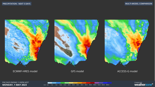
Weatherzone said the heaviest rain will occur over NSW, and hit between Saturday and Monday.
“One area of particular risk for heavy rain and flooding will be the southern half of the NSW coast and adjacent ranges, where a focused stream of onshore winds could produce more than 100mm of rain and possibly more than 200mm in some places,” the weather service said.
There are no flood watches or warnings in place, but Weatherzone said they “may be issued for parts of eastern NSW this weekend”.
The NSW State Emergency Services (SES) is urging communities to “remain vigilant”, warning flash flooding and landslips were possible.
Read Related Also: Merrick Garland kept FBI out of Biden document search
“It is important to prepare your home and items ahead of this forecast, by tying down loose items, parking your car undercover, away from trees and cutting branches that could cause damage to your home,” State Duty Commander Assistant Commissioner Nicole Hogan said.
“Driving during and after a storm can be very dangerous. If you can, delay your trip, and park under cover.
“If you do need to drive, never drive, walk or ride through flood waters.
“If you come across a flooded road, please do not take the risk and find an alternate route.”
The BoM said “there are signs El Niño may form during winter,” adding chances of one this year remain at 50 per cent.

Fishermen stumble on waterspout in the Whitsundays
Sign up here to receive our daily newsletters and breaking news alerts, sent straight to your inbox.