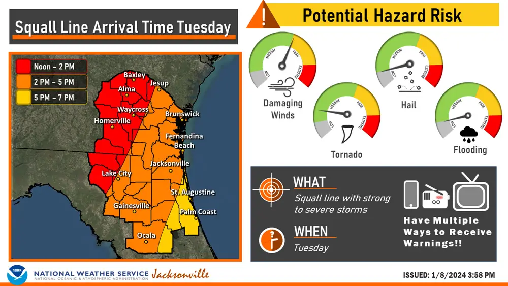
Flagler County Emergency Management Director Jonathan Lord is urging caution and alertness in preparation for a day of stronger-than-usual winds around midday Tuesday, then a squall lines of storms Tuesday evening, especially between 5 and 7 p.m. Relative to the Panhandle, the unsettled weather won;t be as severe in Flagler County, but the most important thing will be to be informed through an alert system, Lord said, as there is a small potential for tornadoes and hail.
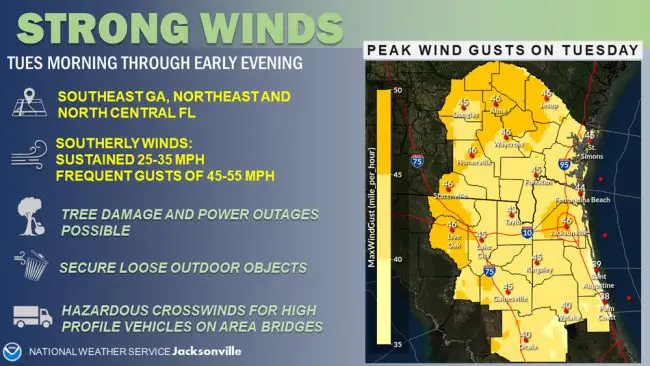
“We’re at at the edge of where it’s going to be but it could very well impact us,” Lord said Monday evening. winds will increase from morning to midday, going from winds of 20 mph during the morning rush to the upper 20s mph from noon to 3 p.m., peaking at around 38 mph. That will be followed by squall lines, which bring thunderstorms and bursts of wind, with a marginal risk of tornadoes. No tornado watch had been issued for the Palm Coast-Flagler County area Tuesday evening, however.
“Our big message to folks is just make sure you have a way to get alerts, our AlertFlagler system, is free,” and provides localized alerts, Lord said. to get localized alerts. You can sign up for AlertFlagler here.
The forecast is for less than an inch of rain for the whole day in the region, as the storms will move through the area quickly. “This is a bigger threat for the Panhandle,” Lord said, but Flagler remains in the risk area. As during any wind event, he is recommending that residents secure outdoor objects.
Flagler County schools announced Monday evening that most Tuesday afterschool activities, including all sports, are cancelled, but extended day–the pre- and afterschool child care program–the Carver Center in Bunnell and the Flagler County Youth Center on the campus of Flagler Palm Coast High School will keep to their regular hours. Classes will convene and release at their regular time, and bus routes will keep their normal schedule.
The National Weather Service in Jacksonville by nightfall Monday was describing a warm front lifting northward through the area, causing isolated strong to severe thunderstorms overnight Monday in southeast Georgia and western Florida, with a potential for a brief tornado or two along with a strong to severe wind gusts of 40-60 mph.
Confidence remains medium to high for the potential for severe weather and strong wind gusts on Tuesday as the squall line sweeps eastward through northeast Florida in the afternoon, ahead of a strong cold front. The Weather Service is predicting “a threat for locally damaging winds 60-80 mph and isolated tornadoes,” but that could be anywhere in the multi-county area of Northeast Florida. Sustained speeds will be more in the 25-35 mph, “with potentially damaging gusts of 45-55 mph developing by the mid to late morning hours across our area.”
There is a window for minor coastal flooding as strong southerly winds and high tide coincide on Tuesday morning and Tuesday evening, but again, stronger impacts around the Jacksonville area and along the St. Johns River basin.
![]()