Last Updated: 8:51 a.m.
Flagler County won’t be spared at least some of the effects of Tropical Storm Idalia, soon to be Hurricane Idalia as the storm’s path arcs somewhat rapidly from Florida’s Big Bend toward northeast Florida and southwest Georgia between Wednesday and Thursday.
“We’re probably going to see a tropical storm here, tropical storm force winds, sustained, that’s very likely,” Flagler County Emergency Management Director Jonathan Lord said early this morning. “So we’re going to ask our community to be prepared for those types of impacts. If we can picture what we saw with Ian and Nicole, but probably less water, maybe a little bit more wind on the west side.”
Both hurricanes Ian and Nicole developed in 2022 and affected the region as tropical storms, Nicole developing late last season, in November, and making landfall in the Big bend area on Nov. 9.
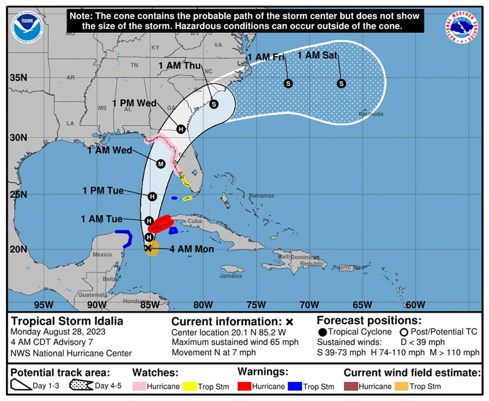
The storm, now forecast to make landfall as a major hurricane somewhere in rural Taylor or Dixie counties, would bring tropical storm force winds and some rain to Flagler County by late Tuesday and Wednesday, according to the National Hurricane Center. Lord does not expect evacuations, but cautions that people in RVs and mobile homes in the western part of the county should be prepared to evacuate, with impacts starting Tuesday night and continuing through Wednesday.
“At this point in time there’s not a storm surge forecast for us, so we shouldn’t see the same kind of water impacts that we saw” with previous, recent tropical storms. That will help with limiting damage to the shore’s vulnerable–and in long stretches, non-existent–dune structure. It will also limit any fears of flooding from the Intracoastal in Flagler Beach. “But today will be very telling with the forecast as it locks in. We’ve been saying it all weekend on social media, which is be prepared.”
Luckily for county and state residents, another suspension of the state sales tax on storm supplies went into effect on Saturday, and will be in place until Sept. 8.
Before dawn Monday, Idalia was churning with 65 miles per hour winds, just short of hurricane force, and was expected to become a Category 1 hurricane within hours. It had been moving lethargically through the Caribbean, but it is now picking up some speed and making a beeline for Florida’s Big Bend, shaving the far western end of Cuba tonight and into tomorrow morning. It will then accelerate north-northeast, according to the Hurricane Center’s consensus forecast.
As always, very small deviations in the storm’s track would mean very large shifts in the path, the further out the path from the deviation. That’s why the cone of probability is as broad as it is, and why it currently includes portions of Flagler County. A very small shift south could result in Idalia’s cone including all of Flagler, just as a very small shift north would spare the entire county, possibly even of tropical storm force winds.
“We are within the cone but I don’t want to see people focus on that cone,” Lord said. “That cone is the eye only, we will see impacts regardless of the cone.” Lord expects rain to total about 2 inches, “a significant amount of rain but not a dangerous amount of rain.” It would fall on grounds that have room for absorption, as it’s been dry for a stretch.
Read Related Also: DeSantis Wants Children to Be Ignorant, Intolerant and Narrow-Minded
The two leading hurricane-forecasting models differ a little over its path. The American model shows Idalia crossing Florida at Big bend in a more northerly arc, with its center staying to the east end of the Panhandle. The European model, which has had a more accurate history over the years, shows the storm’s center passing just northwest Jacksonville. Either way, both models for now show Idalia bringing tropical storm force winds to Flagler, especially its western and northern ends.
Here’s an animated version of the storm’s path according to the European model, courtesy of Tropical Tidbits:
On Sunday, Idalia had been forecast to make landfall as a Category 2 hurricane, but Gov. Ron DeSantis cautioned that with “very, very warm” Gulf of Mexico waters, the storm could intensify. It appears to be doing just that. “Idalia is now forecast to become a major hurricane before it reaches the Gulf coast of Florida,” the National Hurricane Center reports.
A Major hurricane is Category 3, 4 or 5. A Category 3 hurricane packs sustained winds of between 111 and 129 miles per hour. “The risk continues to increase for life-threatening storm surge and dangerous hurricane-force winds along portions of the west coast of Florida and the Florida Panhandle beginning as early as late Tuesday. Storm surge and hurricane watches are in effect for portions of the west coast of Florida and the coast of the Florida Panhandle.”
DeSantis said the state has mobilized 1,100 members of the Florida National Guard, and truck weight limits have been lifted by the Florida Department of Transportation to help speed recovery, according to the News Service of Florida. The center predicted that Idalia will bring 3 to 6 inches of rain to parts of Florida’s west coast and the Panhandle, with some isolated areas topping 10 inches, causing scattered flash flooding and urban flooding. As of Sunday, Flagler County was not among the 33 counties DeSantis included in his declaration of a state of emergency.
“We are in the very edge, I fully expect us to be included today,” Lord said, reflecting conversations he’s had with state management officials.
[This is a developing story. It’ll be updated as necessary.]
![]()
nws-jax-briefing