Heatwave conditions will ease tomorrow for parts of Queensland in a welcome reprieve for residents.
Temperatures are predicted to fall in central northern parts of the state, according to the Bureau of Meteorology, but thunderstorms could roll this afternoon and this evening ahead of the change.
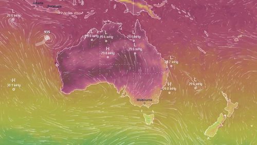
Meteorologist Jonathan How said severe thunderstorms could also hit north-east NSW and Western Australia this afternoon and tonight.
“Keep an eye on any warnings,” How said.
Other parts of Queensland, including the far north Cape York Peninsula and the state’s west, will remain hot tomorrow.
How said a high pressure system in the southern ocean would continue to move towards the east tomorrow, which could cause a surface trough over Western Australia to strengthen.
“That’s funneling heat and humidity down across the west and south-west of the state,” How said.
Severe heatwave conditions with maximum temperatures are expected to continue for Western Australia up to 12 degrees above average tomorrow.
Showers and thunderstorms are expected to become widespread for the state’s Gascoyne and Pilbara in the afternoon, along with the risk of heavy rain through the Pilbara.
The weather system could also push down into the Perth Hills and the state’s Wheatbelt region.
Perth can expect a hot day of 39 degrees with the possibility of a gusty storm for the eastern suburbs in the afternoon.
Meanwhile How said a tropical low in the Indian ocean is “well offshore of the West Australian coastline”.
“At this stage, it does have a low to moderate, or 10 to 25 per cent chance, of developing into a tropical cyclone,” he said.
“It is expected to weaken though as it continues to move away from the country.”