Satellite photos from space have captured incredible “atmospheric ripples” near Western Australia.
The images, from the Himawari-9 satellite, show atmospheric gravity waves, which were triggered by sea breezes and thunderstorms near the Pilbara coast on Friday afternoon.
As the thunderstorms weakened in the evening, they sent currents of cold air rushing towards the surface, reported Weatherzone.
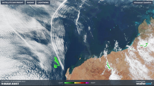
The currents of cold air act in a similar way to a rock being thrown into a body of water.
Read Related Also: Washington Post: The Democrats' Border Problem is Getting Serious
The purple shading in one satellite image indicates the weakening of thunderstorms.
Thin clouds also begin to move away as the system weakens.
“This is the edge of the cold outflow that continued towards the Indian Ocean during Saturday and caused the atmospheric ripples of rising and sinking air,” James Rout from Weatherzone said.