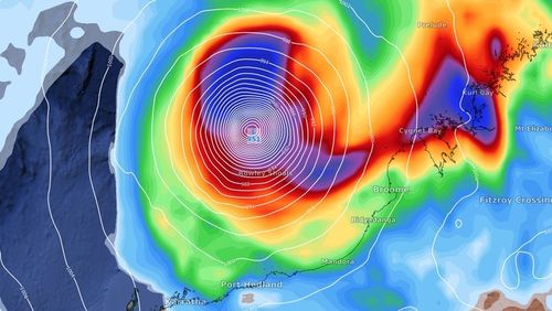
Weatherzone said a tropical low formed on Wednesday night more than 500km north of Darwin in the Arafura Sea which is expected to gain strength while moving south west to the Western Australian coast.
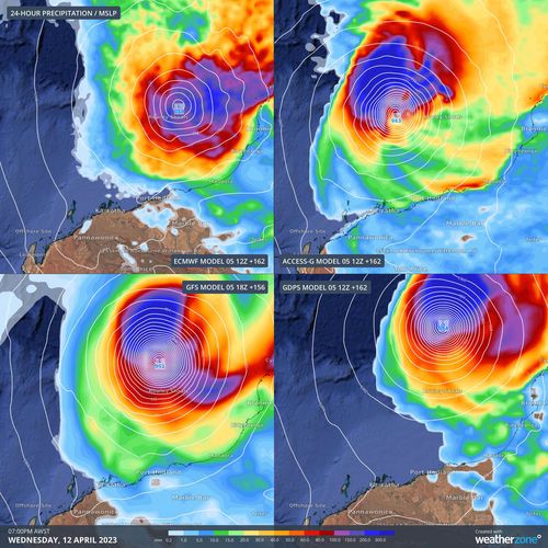
“About half of the main global forecast models expect this system to reach tropical cyclone strength by Monday, and all have it developed into a tropical cyclone by Tuesday,” the forecaster said.
“About half of the models also predict this system will become a category 3 severe tropical cyclone, or higher, mid-to-late next week.”
The northern coast of Western Australia may be impacted as the cyclone makes landfall.
“The highest likelihood of severe weather over land is currently over the Kimberley and/or Pilbara from Thursday onwards,” Weatherzone said.
The cyclone is likely to be named Ilsa.
Read Related Also: Johnny Depp Once Considered Retiring After Questioning His Acting Career as an ‘Insane Option’
There are a couple of other factors leading to the risk of the cyclone including warm ocean temperatures of around 30 degrees, air moving away in the troposphere (the lowest region of the atmosphere) and low to medium amounts of vertical wind shear.
The Bureau of Meteorology’s Miriam Bradbury said it is currently just a tropical low but there is a “fairly high likelihood of this tropical low becoming a tropical cyclone” around Monday or Tuesday.
However, it is hard to tell at this stage the exact intensity or path of the system.
”The message for people in these areas is keep an eye on the bureau’s forecasts and warnings page, particularly that tropical cyclone outlook page so that you can be alerted as soon as possible when and if this system is upgraded to a tropical cyclone,” she said.
It would be the third cyclone to hit Australia this year after Cyclone Ellie caused chaos in Western Australia’s Kimberley region with intense flooding and destruction and Cyclone Gabrielle sweeping across Queensland’s north.

Record heat in NSW sparks bushfires
Sign up here to receive our daily newsletters and breaking news alerts, sent straight to your inbox.