
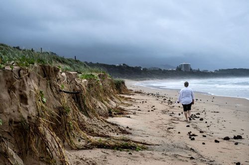
The Bureau of Meteorology has warned rainfall up to 200mm, damaging winds, hazardous surf and coastal erosion will impact millions of residents in NSW.
Wild weather is set to travel down the mid-north coast of Coffs Harbour as far south as Bega, with Sydney also bracing for wet conditions not seen since 2022.
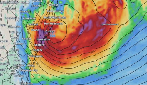
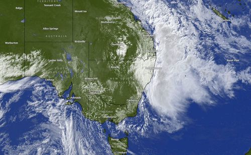
Why is this east coast low so severe?
According to Weatherzone, a weather event known as explosive cyclogenesis is brewing off the NSW Mid North Coast – a process which rapidly intensifies the weather of an east coast low as it approaches land.
A few things stir up an east coast low and can make its coastal approach so damaging.
This includes warm sea surface temperatures, a blocking high-pressure system, temperature instability in the air and an upper trough developing over the Great Dividing Range.
An east coast low is so unusual because it can evolve quite rapidly.
The low develops into a strong low-pressure system, which in turn has quite a large impact with heavy rain, strong winds and wild surf, causing coastal erosion.
These weather systems also only develop near the coast and generally last a minimum of 12 hours.
Where is it going to hit hardest?
The NSW State Emergency Service (SES) has issued a warning for anyone living on the coast between Coffs Harbour and Bega, including metropolitan Sydney.
However, some regions will see more rainfall, gale-force winds and damaging surf.
NSW SES Deputy Commissioner Debbie Platz today said the SES has deployed more personnel and resources into the most impacted areas, including Kiama, Albury, Hawkesbury, Maitland and Dungog.
Helicopters and emergency vehicles have also been directed to Taree, which was hit by a flood disaster in May.
“This is a time for our communities across NSW to be very vigilant and very prepared. We’re looking at thunderstorms, rain, strong winds, coastal erosion and damaging surf,” Platz said.
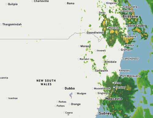
How much rain will we get?
Around 50-120mm of rainfall across the NSW coast is likely, but there is the chance of isolated totals reaching 150-200mm, the Bureau of Meteorology’s Steve Bernasconi warned.
While some rain and wind is expected today, the heaviest weather is expected to hit tomorrow, particularly in Sydney.
Up to 90mm of rain is forecast for the NSW capital in just 24 hours and up to 140mm in total is forecast to lash Sydney over the next few days.
What should I do to prepare my home?
The NSW SES urged impacted residents to prepare for cyclonic conditions.
“We are prepared here, at SES,” Platz said.
“But what we need is for you to be prepared.
“You out there in the community need to start preparing for this weather event.”
Platz warned people to clean gutters, to move or tie down loose items like outdoor furniture and trampolines and to move cars away from large trees.
Residents have also been urged to stay informed via the BoM and SES websites.
When will conditions ease?
East coast lows often intensify quickly over 12 to 24 hours, the bureau said.
Heavy rain and damaging winds are expected to ramp up by tonight, with the most intense weather set to smash the coast by Tuesday afternoon and into Wednesday morning.
The east coast low is forecast to ease by Thursday, however the bureau said the wild weather could hang around until at least Friday.


