
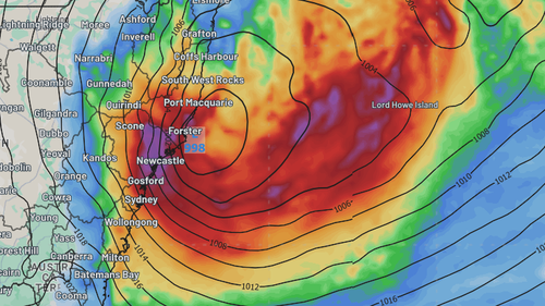
Eastern New South Wales is facing extreme weather in coming days, as a potential east coast low forms of the coast.
The system is expected to hit the state’s Mid North Coast today, with the most intense weather coming to Sydney tomorrow.
The Bureau of Meteorology has issued hazardous wind and surf warnings for the NSW coast.
An initial flood watch warning is also in place for the Hawkesbury-Nepean, Georges, Cooks, Sydney Coast, and Illawarra Coast catchments.
The developing system has been dubbed a potential “bomb cyclone” – a rapidly-forming system that goes from non-existence to threatening in just days.
It could also be the first east coast low to hit Sydney since 2022.
While some rain and wind is expected today, the heaviest weather is expected to hit tomorrow, particularly in Sydney.
Up to 90mm of rain is forecast for the NSW capital in just 24 hours.
Sustained winds of 45km/hr, with gusts of 125km/hr predicted by the Bureau.
The NSW SES this morning has urged millions of residents, from Bega to Coffs Harbour, to prepare for cyclonic conditions.
Stay up to date with warnings and conditions at the BoM and SES websites.