
The rain experienced in Queensland and NSW today is expected to continue into tomorrow and Sunday.
Wet weather should ease up in Queensland from late Saturday morning, while a cool south-westerly front will move over the north-east, bringing cool winds.
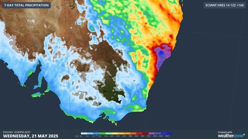
In NSW, a coastal low-pressure system is expected to “develop and deepen” on Sunday, BoM Senior Meteorologist Miriam Bradbury said.
“This will push showers, strong to possibly damaging winds and hazardous surf conditions onto the coast,” Bradbury said.
“The location, development and movement of this system will directly influence the rainfall totals and the impact along the coast.”
The heaviest rainfalls will be seen across southern and central NSW on Sunday.
On Monday and Tuesday, the rainfall will affect the Central, Hunter and Mid North Coasts.
Daily rainfall totals over the weekend will reach at least 50mm along the coast, with localised rainfall expected to be worse.
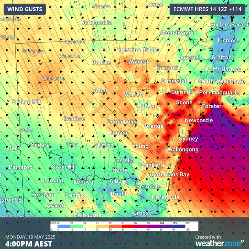
The low-pressure system will create damaging winds and hazardous surf.
“It could generate really dangerous conditions, the winds could produce downed trees.”
On the lower east coast, Tasmania, Victoria and South Australia are bracing for the “coldest weekend” of the year so far, as a cold front moves over the area.
“We’ll see scattered showers and locally gusty winds developing later today and into tomorrow as the front moves through,” Bradbury said.
The cold front could bring hail to Victoria and severe frost to parts of Tasmania.
Daily temperatures are forecast to drop two to five degrees below the May average on Saturday and Sunday.
Nighttime temperatures will plummet to five to zero degrees, while daytime temps will struggle to climb over 16 degrees.
“The cold should start to ease later tomorrow, going into Sunday, as a large high-pressure system pushes in very quickly behind the front and settles conditions down again,” Bradbury said.